IMAGES TAKEN NEAR TO
Scotchmead, EXETER, EX5 2BT
Introduction
This page details the photographs taken nearby to Scotchmead, EX5 2BT by members of the Geograph project.
The Geograph project started in 2005 with the aim of publishing, organising and preserving representative images for every square kilometre of Great Britain, Ireland and the Isle of Man.

There are currently over 7.5m images from over14,400 individuals and you can help contribute to the project by visiting https://www.geograph.org.uk
Image Map
Images are licensed for reuse under creativecommons.org/licenses/by-sa/2.0
Notes
- Clicking on the map will re-center to the selected point.
- The higher the marker number, the further away the image location is from the centre of the postcode.
Image Listing (51 Images Found)
Images are licensed for reuse under creativecommons.org/licenses/by-sa/2.0
Image
Details
Distance
1
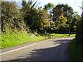
A footpath on a hill
Looking down the hill.
Image: © Anthony Vosper
Taken: 24 Oct 2010
0.02 miles
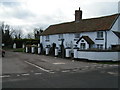
2
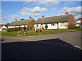
Scotchmead
A Post box and bus stop at the entrance to this small estate.
Image: © Anthony Vosper
Taken: 24 Oct 2010
0.03 miles
3
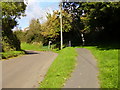
A footpath on a hill
This will give access to the play area.
Image: © Anthony Vosper
Taken: 24 Oct 2010
0.04 miles
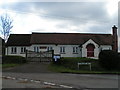
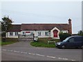
7
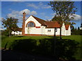
Aylesbeare : Aylesbeare Village Hall
A village hall in the community.
Image: © Lewis Clarke
Taken: 13 May 2018
0.06 miles
8
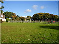
The village play area
Empty on a Sunday afternoon.
Image: © Anthony Vosper
Taken: 24 Oct 2010
0.06 miles
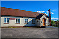
9
The village hall
Situated on Village Way.
Image: © Anthony Vosper
Taken: 24 Oct 2010
0.06 miles
10
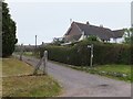
Public footpath into Aylesbeare
The village is to the south of the east-west road through Aylesbeare Cross. This footpath gives access to Scotchmead
Image: © David Smith
Taken: 1 Aug 2011
0.06 miles