IMAGES TAKEN NEAR TO
Aylesbeare, EXETER, EX5 2BP
Introduction
This page details the photographs taken nearby to EX5 2BP by members of the Geograph project.
The Geograph project started in 2005 with the aim of publishing, organising and preserving representative images for every square kilometre of Great Britain, Ireland and the Isle of Man.

There are currently over 7.5m images from over14,400 individuals and you can help contribute to the project by visiting https://www.geograph.org.uk
Image Map
Images are licensed for reuse under creativecommons.org/licenses/by-sa/2.0
Notes
- Clicking on the map will re-center to the selected point.
- The higher the marker number, the further away the image location is from the centre of the postcode.
Image Listing (11 Images Found)
Images are licensed for reuse under creativecommons.org/licenses/by-sa/2.0
Image
Details
Distance
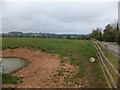
1

Rill Farm
A fine seven-bay façade for this farmhouse by the lane north of Perkin's Village.
Image: © Derek Harper
Taken: 27 Mar 2006
0.02 miles
2

Track at Rill Farm
The track leads to two houses adjacent to Rill Farm
Image: © David Smith
Taken: 1 Aug 2011
0.07 miles
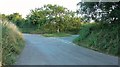
4

Minor road south of Rill Farm
The road is single track with passing places, such as here.
Image: © David Smith
Taken: 1 Aug 2011
0.09 miles
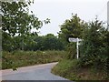
5
Rill Corner
Image from a different angle in late evening light.
Image: © Derek Harper
Taken: 14 Aug 2016
0.12 miles

8
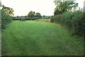
Field near Rill Corner
A small wedge-shaped field by Marwood Lane.
Image: © Derek Harper
Taken: 14 Aug 2016
0.14 miles

10
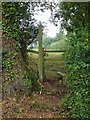
Footpath stile near Rill Cottages
The footpath leads into Aylesbeare from the north-west
Image: © David Smith
Taken: 1 Aug 2011
0.22 miles