IMAGES TAKEN NEAR TO
Bonds Lane, EXETER, EX5 1QF
Introduction
This page details the photographs taken nearby to Bonds Lane, EX5 1QF by members of the Geograph project.
The Geograph project started in 2005 with the aim of publishing, organising and preserving representative images for every square kilometre of Great Britain, Ireland and the Isle of Man.

There are currently over 7.5m images from over14,400 individuals and you can help contribute to the project by visiting https://www.geograph.org.uk
Image Map
Images are licensed for reuse under creativecommons.org/licenses/by-sa/2.0
Notes
- Clicking on the map will re-center to the selected point.
- The higher the marker number, the further away the image location is from the centre of the postcode.
Image Listing (32 Images Found)
Images are licensed for reuse under creativecommons.org/licenses/by-sa/2.0
Image
Details
Distance

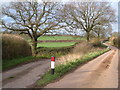
2
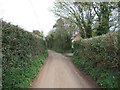
Bond's Lane leading to Woodbury Salterton
Image: © David Smith
Taken: 5 Apr 2011
0.05 miles
4
Orange Way in Devon and Torbay (302)
The footpath from Moor Lane arrives at Bond's Lane. A view the other way is at http://www.geograph.org.uk/photo/2342292.
Image: © Shazz
Taken: 14 Apr 2012
0.08 miles
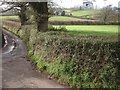
6
Bond's Lane, Woodbury Salterton
The junction with Moor Lane (l) which forms the farm road to Pilehayes Farm. Looking NE.
Image: © Derek Harper
Taken: 27 Mar 2006
0.09 miles
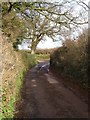
7
Track to Pilehayes Farm
Some maps show the farm as "Lower Pilehayes Farm"
Image: © David Smith
Taken: 5 Apr 2011
0.09 miles
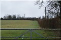
8
Moor Lane
Image: © Derek Harper
Taken: 27 Mar 2006
0.09 miles
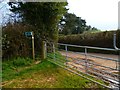
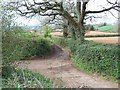
9

Footpath off Bond's Lane
The OS 1:50000 and 1:25000 maps differ in the route taken by this path. The former shows an earlier route, and the path now follows the field boundary as shown on the 1:25000 map. The path leads to Pilehayes Farm
Image: © David Smith
Taken: 5 Apr 2011
0.10 miles
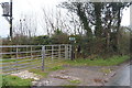
10
Sign on Moor Lane
See Image; in the intervening years, the herd sign for Oakroyal at Pilehayes Farm has either dropped off its twig or been removed. As the similar Image says, the farm, visible in the background, is named Lower Pilehayes Farm on maps. But the nearby Higher Pilehayes Farm continues to exist in its own right. The cattle in question are a herd of prize-winning Holsteins.
Image: © Derek Harper
Taken: 27 Mar 2006
0.10 miles