IMAGES TAKEN NEAR TO
Flower Street, EXETER, EX5 1LY
Introduction
This page details the photographs taken nearby to Flower Street, EX5 1LY by members of the Geograph project.
The Geograph project started in 2005 with the aim of publishing, organising and preserving representative images for every square kilometre of Great Britain, Ireland and the Isle of Man.

There are currently over 7.5m images from over14,400 individuals and you can help contribute to the project by visiting https://www.geograph.org.uk
Image Map
Images are licensed for reuse under creativecommons.org/licenses/by-sa/2.0
Notes
- Clicking on the map will re-center to the selected point.
- The higher the marker number, the further away the image location is from the centre of the postcode.
Image Listing (77 Images Found)
Images are licensed for reuse under creativecommons.org/licenses/by-sa/2.0
Image
Details
Distance

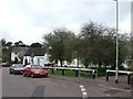
2

Woodbury village hall and toilets
There is a free car park next door.
Image: © Anthony Vosper
Taken: 11 Jan 2012
0.05 miles
3

Woodbury C of E primary school
This is a grade II listed building.
The castle refereed to in Woodbury lane relates to an iron age hill fort, a short distance away.
Image: © Anthony Vosper
Taken: 11 Jan 2012
0.06 miles
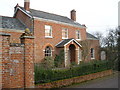
6
Brick house in Woodbury
"A substantially complete example of a small Late Georgian house, with good external and internal detail. The Coade stone design is identical to that used on other houses of this date, most notably in Exeter" http://www.imagesofengland.org.uk/Details/Default.aspx?id=461971&mode=adv . The keystone matches one of the designs used along Southernhay West in Exeter. The house is seen from the other direction in Image
Image: © Derek Harper
Taken: 4 Jan 2010
0.07 miles
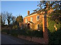
7
Former butcher's, Woodbury
There has been some demolition too.
Image: © Richard Webb
Taken: 19 Apr 2011
0.07 miles
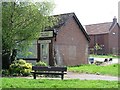
8
The Green
Junction of Parsonage Way and Castle Lane.
Note, the solar powered school sign.
Image: © Anthony Vosper
Taken: 11 Jan 2012
0.07 miles

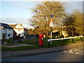
10
Junctions in Woodbury
Greenway passes Haymans Orchard and Castle Lane, with a postbox near the corner. The large cob cottage on the right is listed http://www.imagesofengland.org.uk/Details/Default.aspx?id=88586&mode=adv .
Image: © Derek Harper
Taken: 4 Jan 2010
0.07 miles