IMAGES TAKEN NEAR TO
Woodbury, EXETER, EX5 1LD
Introduction
This page details the photographs taken nearby to EX5 1LD by members of the Geograph project.
The Geograph project started in 2005 with the aim of publishing, organising and preserving representative images for every square kilometre of Great Britain, Ireland and the Isle of Man.

There are currently over 7.5m images from over14,400 individuals and you can help contribute to the project by visiting https://www.geograph.org.uk
Image Map
Images are licensed for reuse under creativecommons.org/licenses/by-sa/2.0
Notes
- Clicking on the map will re-center to the selected point.
- The higher the marker number, the further away the image location is from the centre of the postcode.
Image Listing (42 Images Found)
Images are licensed for reuse under creativecommons.org/licenses/by-sa/2.0
Image
Details
Distance
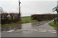
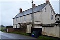
1
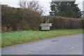
Approaching Higher Venmore farm from the West
On a wet and damp January afternoon.
Image: © Anthony Vosper
Taken: 31 Jan 2017
0.03 miles
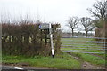
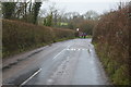
4
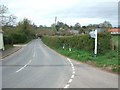
Downs Corner
The junction is by Higher Vermoor Farm, to the south of Woodbury.
Image: © David Smith
Taken: 5 Apr 2011
0.05 miles