IMAGES TAKEN NEAR TO
Woodbury, EXETER, EX5 1JY
Introduction
This page details the photographs taken nearby to EX5 1JY by members of the Geograph project.
The Geograph project started in 2005 with the aim of publishing, organising and preserving representative images for every square kilometre of Great Britain, Ireland and the Isle of Man.

There are currently over 7.5m images from over14,400 individuals and you can help contribute to the project by visiting https://www.geograph.org.uk
Image Map
Images are licensed for reuse under creativecommons.org/licenses/by-sa/2.0
Notes
- Clicking on the map will re-center to the selected point.
- The higher the marker number, the further away the image location is from the centre of the postcode.
Image Listing (11 Images Found)
Images are licensed for reuse under creativecommons.org/licenses/by-sa/2.0
Image
Details
Distance
1
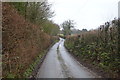
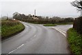
Woodbury : Woodbury Road B3179
Looking along the B3179.
Image: © Lewis Clarke
Taken: 3 Dec 2019
0.07 miles
2
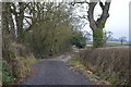
Woodbury : Track
A track heading off from Woodbury Road.
Image: © Lewis Clarke
Taken: 3 Dec 2019
0.09 miles
3
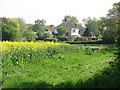
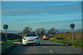
Oilseed rape off Woodbury Road
The galvanised drinking trough shows that this field has been used for grazing.
Image: © Richard Webb
Taken: 19 Apr 2011
0.12 miles

6
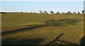
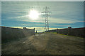
Hillside above South Hill Farm
From Ebford Lane about 200 metres west of Image, looking up a large field towards a little piece of ribbon development on the B3179. The right-hand of the three houses is across a gridline in Image
Image: © Derek Harper
Taken: 4 Jan 2010
0.22 miles