IMAGES TAKEN NEAR TO
Woodmanton, EXETER, EX5 1HG
Introduction
This page details the photographs taken nearby to Woodmanton, EX5 1HG by members of the Geograph project.
The Geograph project started in 2005 with the aim of publishing, organising and preserving representative images for every square kilometre of Great Britain, Ireland and the Isle of Man.

There are currently over 7.5m images from over14,400 individuals and you can help contribute to the project by visiting https://www.geograph.org.uk
Image Map
Images are licensed for reuse under creativecommons.org/licenses/by-sa/2.0
Notes
- Clicking on the map will re-center to the selected point.
- The higher the marker number, the further away the image location is from the centre of the postcode.
Image Listing (7 Images Found)
Images are licensed for reuse under creativecommons.org/licenses/by-sa/2.0
Image
Details
Distance
1
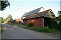
Lower Woodmanton Farm
Lower Woodmanton Farm, Woodbury, Exeter.
Image: © Kevin Hale
Taken: 6 Jun 2006
0.04 miles
2
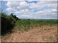
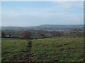
Maize near Woodmanton
A maize field by the junction of Tedstone lane with the lane through Woodmanton, and a distant view across South Devon.
Image: © Derek Harper
Taken: 9 Jul 2010
0.15 miles
3
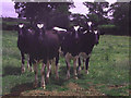
Cows in field off Lympstone-Woodbury minor road
Image: © Peter Duffield
Taken: Unknown
0.16 miles
4

Entrance to Higher Mattocks Farm
Image: © Sarah Charlesworth
Taken: 29 Nov 2009
0.21 miles
5
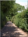
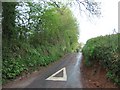
Lane near Woodmanton
This little lane continues the line of Exe View Road north of Stony Lane.
Image: © Derek Harper
Taken: 9 Jul 2010
0.21 miles
6
Fields Leading down to the River Exe
Image: © Sarah Charlesworth
Taken: 1 Dec 2007
0.23 miles