IMAGES TAKEN NEAR TO
Sanctuary Lane, EXETER, EX5 1ET
Introduction
This page details the photographs taken nearby to Sanctuary Lane, EX5 1ET by members of the Geograph project.
The Geograph project started in 2005 with the aim of publishing, organising and preserving representative images for every square kilometre of Great Britain, Ireland and the Isle of Man.

There are currently over 7.5m images from over14,400 individuals and you can help contribute to the project by visiting https://www.geograph.org.uk
Image Map
Images are licensed for reuse under creativecommons.org/licenses/by-sa/2.0
Notes
- Clicking on the map will re-center to the selected point.
- The higher the marker number, the further away the image location is from the centre of the postcode.
Image Listing (16 Images Found)
Images are licensed for reuse under creativecommons.org/licenses/by-sa/2.0
Image
Details
Distance
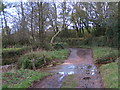

3

Bridge near Winkleigh Farm
A bridge which becomes a ford when the flow of water is too great.
Image: © David Smith
Taken: 5 Apr 2011
0.17 miles
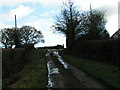
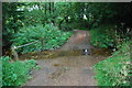
4
Sanctuary lane drops down to cross the Grindle Brook
Image: © Sarah Charlesworth
Taken: 30 Nov 2009
0.18 miles
5
Ford at Greendale
This irish bridge ford is found at Greendale, close to Winkleigh Farm.
Image: © John Walton
Taken: 25 Sep 2013
0.18 miles
6

Vines at Froginwell Vineyard
Besides the vines, this is a hospitality venue
Image: © David Smith
Taken: 23 Aug 2022
0.18 miles
7

Barn at Froginwell Vineyard
Vineyard and hospitality venue
Image: © David Smith
Taken: 23 Aug 2022
0.20 miles