IMAGES TAKEN NEAR TO
Woodbury, EXETER, EX5 1EH
Introduction
This page details the photographs taken nearby to EX5 1EH by members of the Geograph project.
The Geograph project started in 2005 with the aim of publishing, organising and preserving representative images for every square kilometre of Great Britain, Ireland and the Isle of Man.

There are currently over 7.5m images from over14,400 individuals and you can help contribute to the project by visiting https://www.geograph.org.uk
Image Map
Images are licensed for reuse under creativecommons.org/licenses/by-sa/2.0
Notes
- Clicking on the map will re-center to the selected point.
- The higher the marker number, the further away the image location is from the centre of the postcode.
Image Listing (7 Images Found)
Images are licensed for reuse under creativecommons.org/licenses/by-sa/2.0
Image
Details
Distance
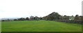
2
A small copse in the corner of a field north of Woodbury
Image: © David Smith
Taken: 13 Nov 2019
0.14 miles
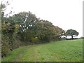
3
Looking south-west across grassland to Woodbury
Image: © David Smith
Taken: 13 Nov 2019
0.17 miles
4
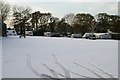
Hardy Souls!
A wintry scene at Brown's Farm Caravan Site, Woodbury Salterton, Devon.
Image: © Kevin Hale
Taken: 26 Nov 2005
0.21 miles
5
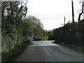
Bend in the road by Brown's Farm, Woodbury Salterton
Image: © Sarah Charlesworth
Taken: 28 Nov 2009
0.22 miles
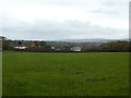
6
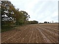
After the maize harvest
A muddy field with the stalks of the maize crop.
Image: © David Smith
Taken: 13 Nov 2019
0.22 miles
7

Whitecross Road/Village Road, Woodbury Salterton
Whitecross Road/Village Road junction, Woodbury Salterton, Devon. The road straight ahead leads to the A3052 Exeter/Sidmouth road, left is the village of Woodbury Salterton, and backwards from the bottom right of the picture (behind the photographer) leads to the village of Woodbury.
Image: © Kevin Hale
Taken: 27 Nov 2005
0.23 miles