IMAGES TAKEN NEAR TO
Cottles Lane, EXETER, EX5 1EE
Introduction
This page details the photographs taken nearby to Cottles Lane, EX5 1EE by members of the Geograph project.
The Geograph project started in 2005 with the aim of publishing, organising and preserving representative images for every square kilometre of Great Britain, Ireland and the Isle of Man.

There are currently over 7.5m images from over14,400 individuals and you can help contribute to the project by visiting https://www.geograph.org.uk
Image Map
Images are licensed for reuse under creativecommons.org/licenses/by-sa/2.0
Notes
- Clicking on the map will re-center to the selected point.
- The higher the marker number, the further away the image location is from the centre of the postcode.
Image Listing (11 Images Found)
Images are licensed for reuse under creativecommons.org/licenses/by-sa/2.0
Image
Details
Distance
1
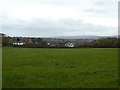
Looking south-west across grassland to Woodbury
Image: © David Smith
Taken: 13 Nov 2019
0.13 miles

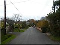
4

Orange Way in Devon and Torbay (306)
The route passed an interesting garden in Cottles Lane.
Image: © Shazz
Taken: 14 Apr 2012
0.16 miles
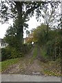
6
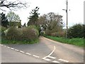
Cottles Lane
The lane leads from near Cottles Farm to the northern outskirts of Woodbury
Image: © David Smith
Taken: 5 Apr 2011
0.17 miles
7
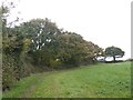
A small copse in the corner of a field north of Woodbury
Image: © David Smith
Taken: 13 Nov 2019
0.19 miles
8
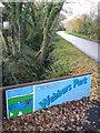
Entrance to Webbers Park crosses the roadside stream
Image: © Sarah Charlesworth
Taken: 28 Nov 2009
0.20 miles