IMAGES TAKEN NEAR TO
Woodbury Salterton, EXETER, EX5 1AL
Introduction
This page details the photographs taken nearby to EX5 1AL by members of the Geograph project.
The Geograph project started in 2005 with the aim of publishing, organising and preserving representative images for every square kilometre of Great Britain, Ireland and the Isle of Man.

There are currently over 7.5m images from over14,400 individuals and you can help contribute to the project by visiting https://www.geograph.org.uk
Image Map
Images are licensed for reuse under creativecommons.org/licenses/by-sa/2.0
Notes
- Clicking on the map will re-center to the selected point.
- The higher the marker number, the further away the image location is from the centre of the postcode.
Image Listing (6 Images Found)
Images are licensed for reuse under creativecommons.org/licenses/by-sa/2.0
Image
Details
Distance
1
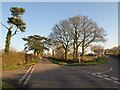
Heathfield Cross
The Lower Road, straight ahead, is the usual route into Woodbury Salterton; on the right is the Higher Road, the one less travelled. To the left is Greendale Lane.
Image: © Derek Harper
Taken: 4 Jan 2010
0.06 miles
2
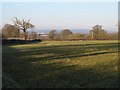
Field near Heathfield House
A view from Higher Road towards Lower Road, which borders the far side of field.
Image: © Derek Harper
Taken: 4 Jan 2010
0.10 miles
3
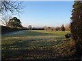
Field by Heathfield Cross
Seen from the immediate left corner of Image, this narrow field has the road to Exeter for its left (southwestern) boundary.
Image: © Derek Harper
Taken: 4 Jan 2010
0.11 miles

5
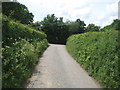
Higher road
A typical hedged Devon lane.
Apart from cow parsley there are few flowers present.
Image: © Anthony Vosper
Taken: 21 May 2017
0.18 miles
