IMAGES TAKEN NEAR TO
Saxon Avenue, EXETER, EX4 9HG
Introduction
This page details the photographs taken nearby to Saxon Avenue, EX4 9HG by members of the Geograph project.
The Geograph project started in 2005 with the aim of publishing, organising and preserving representative images for every square kilometre of Great Britain, Ireland and the Isle of Man.

There are currently over 7.5m images from over14,400 individuals and you can help contribute to the project by visiting https://www.geograph.org.uk
Image Map
Images are licensed for reuse under creativecommons.org/licenses/by-sa/2.0
Notes
- Clicking on the map will re-center to the selected point.
- The higher the marker number, the further away the image location is from the centre of the postcode.
Image Listing (32 Images Found)
Images are licensed for reuse under creativecommons.org/licenses/by-sa/2.0
Image
Details
Distance
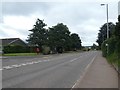
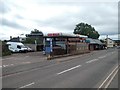
2
Bus stop in Main Road, Pinhoe
The road to the left is Parkers Cross Lane
Image: © John C
Taken: 22 Jul 2019
0.06 miles
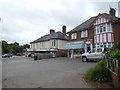
3
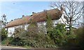
Thatched cottages at Pinn Hill
By the 47 metre spot height on the B3181.
Image: © Christine Johnstone
Taken: 29 Mar 2014
0.09 miles
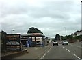
4
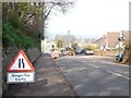
Roadworks on the B3181 at Pinn Hill
Looking northwards.
Image: © Christine Johnstone
Taken: 29 Mar 2014
0.10 miles

8
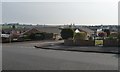
Sunnymoor Close, Pinhoe, Exeter
Running south-west from Parkers Cross Lane.
Image: © Christine Johnstone
Taken: 29 Mar 2014
0.14 miles
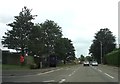
10

Parkers Cross Lane, Pinhoe, Exeter
The circle of tarmac is neither a roundabout nor a junction. Perhaps there was a tree in the middle once?
Image: © Christine Johnstone
Taken: 29 Mar 2014
0.16 miles