IMAGES TAKEN NEAR TO
King Arthurs Road, EXETER, EX4 9DS
Introduction
This page details the photographs taken nearby to King Arthurs Road, EX4 9DS by members of the Geograph project.
The Geograph project started in 2005 with the aim of publishing, organising and preserving representative images for every square kilometre of Great Britain, Ireland and the Isle of Man.

There are currently over 7.5m images from over14,400 individuals and you can help contribute to the project by visiting https://www.geograph.org.uk
Image Map
Images are licensed for reuse under creativecommons.org/licenses/by-sa/2.0
Notes
- Clicking on the map will re-center to the selected point.
- The higher the marker number, the further away the image location is from the centre of the postcode.
Image Listing (3 Images Found)
Images are licensed for reuse under creativecommons.org/licenses/by-sa/2.0
Image
Details
Distance
1

Paths in Mincinglake Valley Park
Image: © Sarah Charlesworth
Taken: 22 May 2009
0.20 miles
2

Mincinglake Valley Park Exeter
In Mincinglake park looking toward Stoke Hill.
Image: © Jan Baker
Taken: 17 Dec 2008
0.21 miles
3
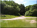
Peace in the city
A quiet track junction at Mincinglake on the outskirts of Exeter.
Image: © Anthony Vosper
Taken: 6 Jul 2014
0.21 miles