IMAGES TAKEN NEAR TO
The Panney, EXETER, EX4 8QT
Introduction
This page details the photographs taken nearby to The Panney, EX4 8QT by members of the Geograph project.
The Geograph project started in 2005 with the aim of publishing, organising and preserving representative images for every square kilometre of Great Britain, Ireland and the Isle of Man.

There are currently over 7.5m images from over14,400 individuals and you can help contribute to the project by visiting https://www.geograph.org.uk
Image Map
Images are licensed for reuse under creativecommons.org/licenses/by-sa/2.0
Notes
- Clicking on the map will re-center to the selected point.
- The higher the marker number, the further away the image location is from the centre of the postcode.
Image Listing (66 Images Found)
Images are licensed for reuse under creativecommons.org/licenses/by-sa/2.0
Image
Details
Distance
1

Tree by car park, Honeylands, Whipton, Exeter
One of several trees preserved in the housing estate
Image: © David Smith
Taken: 17 Nov 2020
0.07 miles
2
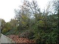
Railway embankment by Honeylands, Whipton, Exeter
Image: © David Smith
Taken: 17 Nov 2020
0.07 miles
3

Honeylands, Pinhoe Road, Exeter
An early C19th villa fronted by a noble Greek Ionic portico. Grade II listed.
It had been used by a local NHS trust as a treatment centre for children with developmental difficulties, but that has gone and the NHS is selling off the whole site.
Image: © Stephen Richards
Taken: 20 Jun 2014
0.08 miles
4
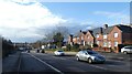
Houses in Whipton Road, beside Pinhoe Road, Exeter
Image: © David Smith
Taken: 6 Feb 2021
0.10 miles
5

Alleyway between railway embankment and houses, Honeylands, Whipton, Exeter
Image: © David Smith
Taken: 17 Nov 2020
0.10 miles
6

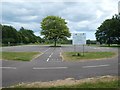
Part of the Hamlin Lane Cycle Pod, Exeter
The tree provides an obstacle for training cyclists to look ahead; on the tarmac is a figure of eight to follow to train in cycle control
Image: © David Smith
Taken: 3 Jun 2019
0.11 miles
7
The Hamlin Lane Cycle Pod, Exeter
An area for training cyclists, with road markings, junctions and cycling challenges
Image: © David Smith
Taken: 3 Jun 2019
0.11 miles
8

A change of name
situated on the junction of Widgery and Pinhoe roads. This corner shop was originally called Wilkes.
Image: © Anthony Vosper
Taken: 3 Apr 2010
0.13 miles
9
Cycle path on Hamlin Lane sports fields, Exeter
Image: © David Smith
Taken: 3 Jun 2019
0.14 miles
10
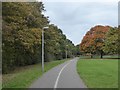
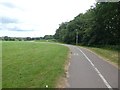
Foot and cyclepath by Hamlin Lane Recreation Ground, Exeter
Image: © David Smith
Taken: 27 Oct 2016
0.14 miles