IMAGES TAKEN NEAR TO
Thursby Walk, EXETER, EX4 8FH
Introduction
This page details the photographs taken nearby to Thursby Walk, EX4 8FH by members of the Geograph project.
The Geograph project started in 2005 with the aim of publishing, organising and preserving representative images for every square kilometre of Great Britain, Ireland and the Isle of Man.

There are currently over 7.5m images from over14,400 individuals and you can help contribute to the project by visiting https://www.geograph.org.uk
Image Map
Images are licensed for reuse under creativecommons.org/licenses/by-sa/2.0
Notes
- Clicking on the map will re-center to the selected point.
- The higher the marker number, the further away the image location is from the centre of the postcode.
Image Listing (62 Images Found)
Images are licensed for reuse under creativecommons.org/licenses/by-sa/2.0
Image
Details
Distance
2

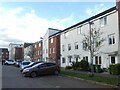
Thursby Walk, Pinhoe, Exeter
A 21st century development of town houses
Image: © David Smith
Taken: 6 Feb 2021
0.05 miles
4
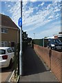
Cycle route and footpath off Chancel Lane, Pinhoe
Image: © David Smith
Taken: 31 Jul 2020
0.08 miles
5
Chancel Bridge
Chancel railway Bridge, Chancel Lane, near Venny Bridge on the Pinhoe Rd. Exeter.
Image: © Jan Baker
Taken: 17 Jan 2009
0.09 miles
6
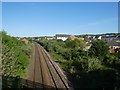
Railway line to Exeter, from Pinhoe railway bridge
Image: © David Smith
Taken: 12 May 2020
0.09 miles
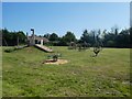
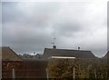
8
The America Hall, Pinhoe
Another view is at Image
Image: © David Smith
Taken: 31 Jul 2020
0.10 miles

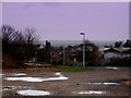
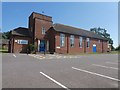
10

Pinbridge Mews, Pinhoe
Why is the title "mews" so widely used out of context?
Image: © David Smith
Taken: 12 May 2020
0.11 miles