IMAGES TAKEN NEAR TO
Pinhoe Road, EXETER, EX4 7HS
Introduction
This page details the photographs taken nearby to Pinhoe Road, EX4 7HS by members of the Geograph project.
The Geograph project started in 2005 with the aim of publishing, organising and preserving representative images for every square kilometre of Great Britain, Ireland and the Isle of Man.

There are currently over 7.5m images from over14,400 individuals and you can help contribute to the project by visiting https://www.geograph.org.uk
Image Map
Images are licensed for reuse under creativecommons.org/licenses/by-sa/2.0
Notes
- Clicking on the map will re-center to the selected point.
- The higher the marker number, the further away the image location is from the centre of the postcode.
Image Listing (108 Images Found)
Images are licensed for reuse under creativecommons.org/licenses/by-sa/2.0
Image
Details
Distance
1
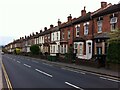
Late Victorian terraced housing, Pinhoe Road, Exeter
Image: © A J Paxton
Taken: 23 Jun 2021
0.00 miles
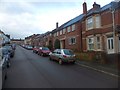
2
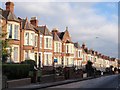
Pinhoe Road, Exeter
This is the B3212, the main road leading out of Exeter towards Cullompton. Here it descends from Mount Pleasant through the terraces of Polsloe. The terrace shown is made up of 43 properties.
Image: © Derek Harper
Taken: 5 Jan 2009
0.02 miles
3
Junction of Commin's Road with Pinhoe Road, Exeter
Turn left for the city centre.
Image: © Jonathan Billinger
Taken: 11 Dec 2008
0.04 miles
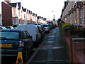
4
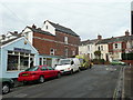
St. Anne's Road, Polsloe, Exeter
Judging by the parked cars it's not completely closed!
Early 20th century terraced housing a mile east of the city centre.
Image: © Jonathan Billinger
Taken: 11 Dec 2008
0.05 miles
5
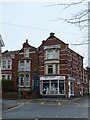
Electrical retailer, Pinhoe Road, Exeter
Corner shop at the end of a row of terraced houses; notable detailing in the brickwork
Image: © David Smith
Taken: 1 Jan 2023
0.06 miles
7
Manston Road, Exeter
The terraced houses were built at the end of the 19th century and start of the 20th century. However, space was left for a church hall, which was used as a place of worship. When the hall was demolished, the houses on the right were built to fill the gap. The foundation stone of the hall is at St Mark's church Image
Image: © David Smith
Taken: 5 Dec 2012
0.07 miles
8
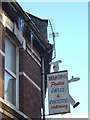
Icicles and shop sign in Pinhoe Road
The wall faces north, and the icicles have accumulated over a week, as the snow on the roof has melted and dripped.
Image: © David Smith
Taken: 25 Dec 2010
0.07 miles
9
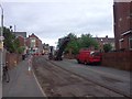
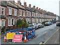
Road resurfacing, St Mark's Avenue, Exeter
Looking towards the junction with Pinhoe Road, where temporary traffic lights control vehicles past the end of the section which has been stripped
Image: © David Smith
Taken: 29 Jul 2015
0.07 miles
10
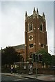
St Mark's Church, Exeter
Church built in the 1930's; it is built of brick, and the quality of the brickwork is very high.
Image: © David Smith
Taken: 10 Sep 2005
0.07 miles