IMAGES TAKEN NEAR TO
Prince Charles Road, EXETER, EX4 7EW
Introduction
This page details the photographs taken nearby to Prince Charles Road, EX4 7EW by members of the Geograph project.
The Geograph project started in 2005 with the aim of publishing, organising and preserving representative images for every square kilometre of Great Britain, Ireland and the Isle of Man.

There are currently over 7.5m images from over14,400 individuals and you can help contribute to the project by visiting https://www.geograph.org.uk
Image Map
Images are licensed for reuse under creativecommons.org/licenses/by-sa/2.0
Notes
- Clicking on the map will re-center to the selected point.
- The higher the marker number, the further away the image location is from the centre of the postcode.
Image Listing (43 Images Found)
Images are licensed for reuse under creativecommons.org/licenses/by-sa/2.0
Image
Details
Distance
1
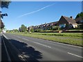
Sheltered housing by Prince Charles Road, Exeter
Image: © David Smith
Taken: 12 May 2020
0.03 miles
2
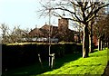
Saint James's Church
St.James's Church is at the end of Prince Charles Road by the roundabout where old Tiverton, Stoke Hill, Mount Pleasant, Union, roads converge. St. James district Exeter.
Image: © Jan Baker
Taken: 6 Dec 2008
0.07 miles
3
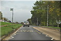
Exeter : Prince Charles Road
Prince Charles Road heading through the city of Exeter.
Image: © Lewis Clarke
Taken: 22 Oct 2013
0.09 miles
4
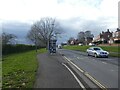
Cycle route and bus shelter, Prince Charles Road, Exeter
Image: © David Smith
Taken: 6 Feb 2021
0.10 miles


7

Bus shelter, Prince Charles Road, Exeter
The cycle path curves round behind it; fortunately, few cyclists use it to descent the slope, so it doesn't matter much that the view is obscured
Image: © David Smith
Taken: 5 Apr 2020
0.11 miles

9
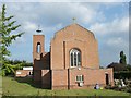
St James' Church, Exeter
The church is post-1945, replacing the church destroyed during world war 2. Exeter City football ground is "St James' Park", as it was close to the old church.
Image: © David Smith
Taken: 8 Sep 2007
0.12 miles
10
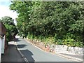
Foot of Rosebarn Lane, Exeter
This section is one way (up the hill). The right hand side wall is an old sandstone wall.
Image: © David Smith
Taken: 22 Jul 2009
0.12 miles