IMAGES TAKEN NEAR TO
Blackboy Road, EXETER, EX4 6TB
Introduction
This page details the photographs taken nearby to Blackboy Road, EX4 6TB by members of the Geograph project.
The Geograph project started in 2005 with the aim of publishing, organising and preserving representative images for every square kilometre of Great Britain, Ireland and the Isle of Man.

There are currently over 7.5m images from over14,400 individuals and you can help contribute to the project by visiting https://www.geograph.org.uk
Image Map
Images are licensed for reuse under creativecommons.org/licenses/by-sa/2.0
Notes
- Clicking on the map will re-center to the selected point.
- The higher the marker number, the further away the image location is from the centre of the postcode.
Image Listing (180 Images Found)
Images are licensed for reuse under creativecommons.org/licenses/by-sa/2.0
Image
Details
Distance
1
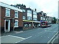
Shop and takeaway, Blackboy Road, Exeter
Image: © David Smith
Taken: 16 Aug 2020
0.02 miles
2

The junction of Pinhoe Road and Mount Pleasant Road
The road straight on becomes Blackboy Road while left is Polsloe Road.
Image: © Bill Boaden
Taken: 29 Jun 2011
0.03 miles
3
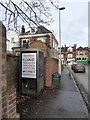
Telephone Box, Polsloe Road, Exeter
A little-used telephone box, filled with drifted leaves. The student shared houses around it remain, but students now use other means of communication. Beyond is the junction at Mount Pleasant, with the Beer Box off licence and Henry's Bar inn
Image: © David Smith
Taken: 25 Nov 2015
0.03 miles
4

Henry's Bar
Colourful corner pub on Mount Pleasant Road.
Image: © Des Blenkinsopp
Taken: 22 Aug 2016
0.04 miles
5

Henry's Bar, Mount Pleasant, Exeter
The inn was formerly known as the Mount Pleasant, and the silver shield on the wall above the pedestrian formerly showed the date 1898. The roofline has several curious spikes
Image: © David Smith
Taken: 18 Apr 2014
0.04 miles
6
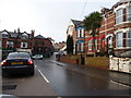
Exeter : Polsloe Road
A lot of student lets on the side of the road with Henrys Bar on Black Boy Road ahead of us.
Image: © Lewis Clarke
Taken: 24 Feb 2010
0.04 miles
7

Pinhoe Road, Mount Pleasant, Exeter
At the crossroads, Pinhoe Road becomes Blackboy Road which leads into the centre of the city of Exeter. Formerly there was a toll gate at this site. There was a Methodist church on the site now occupied by the flats on the right.
Image: © David Smith
Taken: 3 Apr 2015
0.04 miles
8

Mount Pleasant Road, Exeter
A terrace with ornamental gables, and on the right, Watermore Court, modern flats which are close to the junction with Blackboy Road.
Image: © Derek Harper
Taken: 18 Dec 2006
0.04 miles

10

Cafe and terraced houses, Polsloe Road, Exeter
Image: © David Smith
Taken: 16 Aug 2020
0.04 miles