IMAGES TAKEN NEAR TO
Spinning Path, Blackboy Road, EXETER, EX4 6SN
Introduction
This page details the photographs taken nearby to Spinning Path, Blackboy Road, EX4 6SN by members of the Geograph project.
The Geograph project started in 2005 with the aim of publishing, organising and preserving representative images for every square kilometre of Great Britain, Ireland and the Isle of Man.

There are currently over 7.5m images from over14,400 individuals and you can help contribute to the project by visiting https://www.geograph.org.uk
Image Map
Images are licensed for reuse under creativecommons.org/licenses/by-sa/2.0
Notes
- Clicking on the map will re-center to the selected point.
- The higher the marker number, the further away the image location is from the centre of the postcode.
Image Listing (324 Images Found)
Images are licensed for reuse under creativecommons.org/licenses/by-sa/2.0
Image
Details
Distance
1

Horse & Dray, Blackboy Road
It was named the Royal Oak between 1785 and 1799. From 1799 and 1831 it was the Temeraire and then the George & Dragon from 1831 to 1967.
Image: © Peter Holmes
Taken: 19 Mar 2009
0.00 miles
2

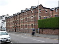
Kendall Close, Blackboy Road
Victorian social housing for working families.
Image: © Des Blenkinsopp
Taken: 21 Aug 2016
0.01 miles
3
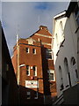
Moose Hall, Spinning Path
Spinning Path is a tiny C19 close off Blackboy Road in Exeter which ends at the Moose Hall, housed in the former St James' Mission Rooms.
Image: © Derek Harper
Taken: 18 Dec 2006
0.01 miles
4
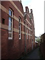
Rear of Moose Hall, Exeter
The rear of the building shown in Image, where it overlooks an alley connecting Toronto Road with Old Tiverton Road.
Image: © Derek Harper
Taken: 28 Feb 2007
0.01 miles
5

The Bowling Green
A cheerful-looking pub on Blackboy Road, Exeter. Until 1987 this was called The Ropemaker's Arms. Although it is now named after Image on the opposite side of Blackboy Road, the pub sign shows Drake's famous game of bowls on Plymouth Hoe.
Image: © Derek Harper
Taken: 18 Dec 2006
0.01 miles
6
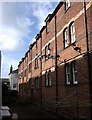
Kendall Close, Exeter
The terrace seen on the left in Image It faces a similar terrace, which backs onto Blackboy Road; they were built in 1876 by the Improved Industrial Dwellings Company, founded to improve the standard of workers' homes. There is some confusion about the name - Kendal and Kendals also appear in documents and on maps.
Image: © Derek Harper
Taken: 28 Feb 2007
0.01 miles
7
Black Boy Road, Exeter
This interesting row of houses caught my eye. I know nothing of the history but they do look a bit like converted warehouses. Contributor David Smith's caption informs me they are Kendall's Building, (or the "Improved Industrial Dwellings"), built in 1876 as a part of a plan 'providing commodious and healthy dwellings for the poor classes'.
Image: © Chris Allen
Taken: 26 Dec 2015
0.02 miles
8

Kendall Close, Blackboy Road, Exeter
Workers' housing of 1876 by the Improved Industrial Dwellings Company. Two parallel ranges.
Image: © Stephen Richards
Taken: 19 Jun 2014
0.02 miles
9

The Horse and Dray, Blackboy Road, Exeter
Delivery time at this old pub on Blackboy Road.
Image: © Derek Harper
Taken: 18 Dec 2006
0.02 miles
10

Horse and Dray, Exeter
Another view of the pub shown at http://www.geograph.org.uk/search.php?i=25176571 . Historical details at http://www.exetermemories.co.uk/em/_pubs/horsedray.php .
Image: © Derek Harper
Taken: 5 Jun 2006
0.02 miles