IMAGES TAKEN NEAR TO
Well Street, EXETER, EX4 6QB
Introduction
This page details the photographs taken nearby to Well Street, EX4 6QB by members of the Geograph project.
The Geograph project started in 2005 with the aim of publishing, organising and preserving representative images for every square kilometre of Great Britain, Ireland and the Isle of Man.

There are currently over 7.5m images from over14,400 individuals and you can help contribute to the project by visiting https://www.geograph.org.uk
Image Map
Images are licensed for reuse under creativecommons.org/licenses/by-sa/2.0
Notes
- Clicking on the map will re-center to the selected point.
- The higher the marker number, the further away the image location is from the centre of the postcode.
Image Listing (271 Images Found)
Images are licensed for reuse under creativecommons.org/licenses/by-sa/2.0
Image
Details
Distance
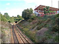
1
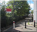
Powderham Crescent, St James, Exeter
Viewed from Well Street. Ahead for the entrance to platform 2 at St James Park railway station.
Image: © Jaggery
Taken: 26 Aug 2016
0.01 miles
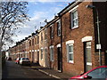
2

The Tannery, Well Street, St James, Exeter
The flats at 49 Well Street are near St James Park (on the left), Exeter City's home ground.
Image: © Jaggery
Taken: 26 Aug 2016
0.02 miles
3
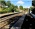
St James Park railway station, Exeter
Viewed from platform 1, for trains to Exeter Central, Exeter St Davids etc, behind the camera.
St James Park is an unstaffed suburban station in Exeter, below St James Park, http://www.geograph.org.uk/photo/5090528 Exeter City's home ground. The station's identifier code is SJP. Its classification is F2, the lowest classification, which indicates a small unstaffed station with fewer than 100,000 passengers boarding or leaving a train per year.
The bridge carries Well Street over the railway.
Image: © Jaggery
Taken: 26 Aug 2016
0.02 miles
4
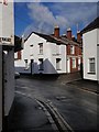
Well Street / Rosewood Terrace, Exeter
Approaching the northern end of Image, after it has crossed the railway line at St James Park station. Here it passes the end of Rosewood Terrace on the right.
Image: © Derek Harper
Taken: 9 Dec 2008
0.02 miles
5
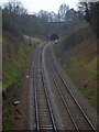
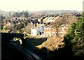
The Mount Pleasant railway tunnel
The line to Exmouth and Waterloo passes under Mount Pleasant Road through this short tunnel
Image: © David Smith
Taken: 8 Apr 2013
0.03 miles
6

Platform 1, St James Park railway station, Exeter
This platform is for trains to Exeter Central, Exeter St Davids etc.
The road bridge carries Well Street over the railway.
The edge of St James Park, http://www.geograph.org.uk/photo/5090528 Exeter City's home ground, is on the right.
Image: © Jaggery
Taken: 26 Aug 2016
0.03 miles
7
Railway line passing St James' Park, Exeter
The eastern stand at Exeter City F.C. overlooking a cutting on the Exeter - Waterloo or Exmouth railway line between St James' Park station and the tunnel under Mount Pleasant.
Image: © Derek Harper
Taken: 2 Oct 2006
0.03 miles
8
South View Terrace, Exeter
This terrace, a continuation of Victoria Street, faces the railway cutting close to St James' Park station.
Image: © Derek Harper
Taken: 12 Dec 2006
0.03 miles
9
Railway Bridge Exeter
This photograph taken in Old Tiverton Road at the junction with Prospect Park near St James's park football stadium.
Image: © Jan Baker
Taken: 6 Dec 2008
0.03 miles
10
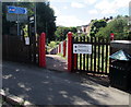
Entrance path down to platform 1, St James Park railway station, Exeter
From Well Street opposite St James Park Stadium, http://www.geograph.org.uk/photo/5090528 the home ground of Exeter City football club.
Platform 1 is for trains to Exeter Central, Exeter St Davids etc.
The entrance to platform 2 for trains to Exmouth is from Powderham Crescent.
Image: © Jaggery
Taken: 26 Aug 2016
0.03 miles