IMAGES TAKEN NEAR TO
Well Street, EXETER, EX4 6PZ
Introduction
This page details the photographs taken nearby to Well Street, EX4 6PZ by members of the Geograph project.
The Geograph project started in 2005 with the aim of publishing, organising and preserving representative images for every square kilometre of Great Britain, Ireland and the Isle of Man.

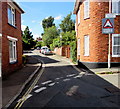
There are currently over 7.5m images from over14,400 individuals and you can help contribute to the project by visiting https://www.geograph.org.uk
Image Map
Images are licensed for reuse under creativecommons.org/licenses/by-sa/2.0
Notes
- Clicking on the map will re-center to the selected point.
- The higher the marker number, the further away the image location is from the centre of the postcode.
Image Listing (251 Images Found)
Images are licensed for reuse under creativecommons.org/licenses/by-sa/2.0
Image
Details
Distance
1
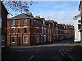
Devonshire Place, St James, Exeter
The southeast end of Devonshire Place viewed from the corner of Well Street and Victoria Road.
Image: © Jaggery
Taken: 26 Aug 2016
0.01 miles
2
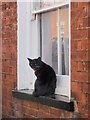
Cat, Victoria Road, Exeter
This cat was rather expecting me to let it in - or remove myself from the area.
Image: © Derek Harper
Taken: 9 Dec 2008
0.01 miles
3
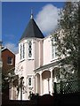
House in Devonshire Place, Exeter
No 23 is specially mentioned in the appraisal of the Longbrook conservation area: "a significant listed building with a tower and pretty architectural detailing". http://www.exeter.gov.uk/media/pdf/g/f/longbrook_draft_01-09-05.pdf . No date is given, but it must be early C19.
Image: © Derek Harper
Taken: 27 Feb 2008
0.02 miles
4

Victoria Road, Exeter
Extra wide three-bayed terraced houses on the west side of this street in St James.
Image: © Derek Harper
Taken: 9 Dec 2008
0.02 miles
5

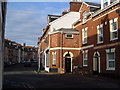
Houses on the west side of Victoria Road, St James, Exeter
Viewed from the corner of Well Street. The humps warning sign is for Devonshire Place. http://www.geograph.org.uk/photo/5163170
Image: © Jaggery
Taken: 26 Aug 2016
0.02 miles
6
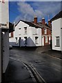
Well Street / Rosewood Terrace, Exeter
Approaching the northern end of Image, after it has crossed the railway line at St James Park station. Here it passes the end of Rosewood Terrace on the right.
Image: © Derek Harper
Taken: 9 Dec 2008
0.02 miles
7
Springfield Road, Exeter
From Prospect Park, looking across the junction with Culverland Road. The St James area of Exeter contains many C19 terraces.
Image: © Derek Harper
Taken: 12 Dec 2006
0.03 miles
8

Culverland Road, Exeter
A view in St James, with Springfield Road going off to the left. The buildings on either side can be seen in Image
Image: © Derek Harper
Taken: 12 Dec 2006
0.03 miles
9
Junction of Victoria Street with Victoria Road, Exeter
A little kink in Victoria Street as it passes Victoria Road on the left. A street scene in the midst of the St James district of Exeter.
Image: © Derek Harper
Taken: 12 Dec 2006
0.03 miles
10

Rosewood Terrace, Exeter
Cul-de-sac extending for 35 metres from Well Street.
Image: © Jaggery
Taken: 26 Aug 2016
0.03 miles