IMAGES TAKEN NEAR TO
Springfield Road, EXETER, EX4 6JL
Introduction
This page details the photographs taken nearby to Springfield Road, EX4 6JL by members of the Geograph project.
The Geograph project started in 2005 with the aim of publishing, organising and preserving representative images for every square kilometre of Great Britain, Ireland and the Isle of Man.

There are currently over 7.5m images from over14,400 individuals and you can help contribute to the project by visiting https://www.geograph.org.uk
Image Map
Images are licensed for reuse under creativecommons.org/licenses/by-sa/2.0
Notes
- Clicking on the map will re-center to the selected point.
- The higher the marker number, the further away the image location is from the centre of the postcode.
Image Listing (182 Images Found)
Images are licensed for reuse under creativecommons.org/licenses/by-sa/2.0
Image
Details
Distance
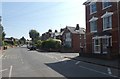
1
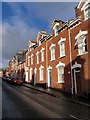
Springfield Road, Exeter
The sunny side of Image, at least, for most of the day. This terrace is a mere 20 houses long compared with the 29-er opposite.
Image: © Derek Harper
Taken: 9 Dec 2008
0.02 miles
2

Culverland Road, Exeter
This curving terrace leads to the junction shown in Image
Image: © Derek Harper
Taken: 18 Dec 2006
0.02 miles
3
Semis on Culverland Road, Exeter
Two of three pairs of semi-detached houses that give way to the older terrace in Image
Image: © Derek Harper
Taken: 18 Dec 2006
0.02 miles
4

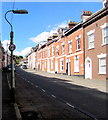
Springfield Road, Exeter
A view of Image from part way up the street. Two row of brick terraces face one another, gently curving as they climb towards Union Road. The left terrace is 29 houses long.
Image: © Derek Harper
Taken: 9 Dec 2008
0.03 miles
5

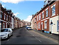
Culverland Road, Exeter
A street with terraced houses in a single style; the exception in this view is the second on the left. The facade was changed to give fake stone cladding, later removed, leaving the plain facade. Much of this area is student housing
Image: © David Smith
Taken: 19 Feb 2022
0.04 miles
6
Up Victoria Street, Exeter
In the St James area of Exeter, Victoria Street ascends towards Union Road.
Image: © Jaggery
Taken: 26 Aug 2016
0.05 miles
7
Inconspicuous speed limit sign, Victoria Street, Exeter
A small sign showing 20 (mph) is on a lamppost alongside an on-street parking area.
Image: © Jaggery
Taken: 26 Aug 2016
0.05 miles
8
Union Road junction with Culverland Road, Exeter
Image: © David Smith
Taken: 23 Apr 2020
0.06 miles
9

Victoria Street, Exeter
Descending from Union Street past Saunders http://www.geograph.org.uk/photo/5090470 on the left and the Victoria Inn http://www.geograph.org.uk/photo/5090485 on the right.
Image: © Jaggery
Taken: 26 Aug 2016
0.06 miles
10

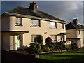
Culverland Close, Exeter
A small housing development (probably from the 1970s)
Image: © David Smith
Taken: 2 Apr 2013
0.07 miles