IMAGES TAKEN NEAR TO
Sylvan Avenue, EXETER, EX4 6ES
Introduction
This page details the photographs taken nearby to Sylvan Avenue, EX4 6ES by members of the Geograph project.
The Geograph project started in 2005 with the aim of publishing, organising and preserving representative images for every square kilometre of Great Britain, Ireland and the Isle of Man.

There are currently over 7.5m images from over14,400 individuals and you can help contribute to the project by visiting https://www.geograph.org.uk
Image Map
Images are licensed for reuse under creativecommons.org/licenses/by-sa/2.0
Notes
- Clicking on the map will re-center to the selected point.
- The higher the marker number, the further away the image location is from the centre of the postcode.
Image Listing (48 Images Found)
Images are licensed for reuse under creativecommons.org/licenses/by-sa/2.0
Image
Details
Distance
1
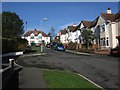
Sylvan Avenue, Exeter
The top half of Image, characterised by the handy provision of two turning circles.
Image: © Derek Harper
Taken: 4 Feb 2008
0.01 miles
2

Sylvan Avenue, Exeter
Typical suburban cul-de-sac in the comfortable Pennsylvania area of northern Exeter.
Image: © Derek Harper
Taken: 10 May 2006
0.05 miles
3

Road junction on Sylvan Road, Exeter
Sylvan Road winds up Pennsylvania Hill, Exeter. Here two roads branch off; ahead is Brodick Close, to the left is Higher Kings Avenue
Image: © David Smith
Taken: 7 Sep 2018
0.07 miles
4

Construction work in a three storey terrace
The house was being repaired and the front garden was filled with material
Image: © David Smith
Taken: 7 Sep 2018
0.09 miles
5

Brodick Close and Elmdon Close, Exeter
Looking west along Brodick Close which is a cul-de-sac linked to Elmdon Close (another cul-de-sac) by a footpath and grass area. The pavement on the left is overgrown with moss. At the further end of the link there is a "No Cycling" sign, but no such sign at the nearer end
Image: © David Smith
Taken: 13 Jan 2018
0.09 miles
6
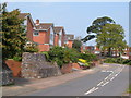
Rosebarn Lane, Exeter
A road that climbs out of northern Exeter from St James into the Pennsylvania area.
Image: © Derek Harper
Taken: 10 May 2006
0.10 miles
7
Sylvan Road, Exeter
Two contrasting Victorian terraces on opposite sides of a road that climbs the hill into the Pennsylvania area. The further row is in Image
Image: © Derek Harper
Taken: 4 Feb 2008
0.12 miles
8

Rosebarn Park, off Rosebarn Lane, Exeter
According to W G Hoskins, Rosebarn Lane takes its name from Rowe's Barn Lane. Rowe was an Exeter butcher who bought the land here, and built a barn in about 1700. Rosebarn Park is a private road.
Image: © David Smith
Taken: 22 Jul 2009
0.14 miles
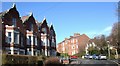
9
Pennsylvania Park, Exeter
The "piece de resistance of Regency Exeter", say Cherry and Pevsner of this tall terrace built in 1821. This view is from Beech Avenue of the eastern end of the six houses; these have a section set back to give the illusion of being detached. They command a fine view over the city.
Image: © Derek Harper
Taken: 13 Feb 2008
0.15 miles
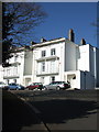
10

1-6 Pennsylvania Park, Exeter
The "pièce de résistance of Regency Exeter, built in 1821 and apparently designed by John Brown of Exeter for Joseph Sparkes, a Quaker banker who lived in one of the houses, and named the terrace after William Penn's New England settlement". Only six of the eight planned houses were built, and together with other alterations it means that as a whole the effect now is "neither as intended, nor as built", even if each house no doubt remains a des res.
Image: © Stephen Richards
Taken: 19 Jun 2014
0.16 miles