IMAGES TAKEN NEAR TO
Wrefords Lane, EXETER, EX4 5BR
Introduction
This page details the photographs taken nearby to Wrefords Lane, EX4 5BR by members of the Geograph project.
The Geograph project started in 2005 with the aim of publishing, organising and preserving representative images for every square kilometre of Great Britain, Ireland and the Isle of Man.

There are currently over 7.5m images from over14,400 individuals and you can help contribute to the project by visiting https://www.geograph.org.uk
Image Map
Images are licensed for reuse under creativecommons.org/licenses/by-sa/2.0
Notes
- Clicking on the map will re-center to the selected point.
- The higher the marker number, the further away the image location is from the centre of the postcode.
Image Listing (16 Images Found)
Images are licensed for reuse under creativecommons.org/licenses/by-sa/2.0
Image
Details
Distance
1
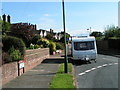
West Garth Road leading into Allington Mead
Image: © Rob Purvis
Taken: 13 Aug 2009
0.03 miles
3
![Well Garth Road, Exeter [1]](https://s1.geograph.org.uk/geophotos/03/91/15/3911557_e30c4403_120x120.jpg)
Well Garth Road, Exeter [1]
Bungalows on the east side, near the junction with Wrefords Lane, at the very top of the estate.
Image: © Christine Johnstone
Taken: 29 Mar 2014
0.06 miles
4
![West Garth Road, Exeter [2]](https://s3.geograph.org.uk/geophotos/03/91/15/3911563_dfcda96a_120x120.jpg)
West Garth Road, Exeter [2]
Looking west from the junction with Allington Mead, near the top of the estate.
Image: © Christine Johnstone
Taken: 29 Mar 2014
0.06 miles
5
![Well Garth Road, Exeter [3]](https://s3.geograph.org.uk/geophotos/03/91/22/3912211_28829c65_120x120.jpg)
Well Garth Road, Exeter [3]
Heading south-west, down the hillside.
Image: © Christine Johnstone
Taken: 29 Mar 2014
0.09 miles
6
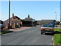
Barton Place Farm Shop
At the 73 metre spot height, at the junction of Wrefords Lane and West Garth Road.
Image: © Christine Johnstone
Taken: 29 Mar 2014
0.10 miles
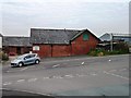
7
Barton Place Farm Shop
On Wreford's Lane.
Image: © Rod Allday
Taken: 1 Nov 2015
0.10 miles
8
![Well Garth Road, Exeter [4]](https://s1.geograph.org.uk/geophotos/03/91/22/3912217_118693d4_120x120.jpg)
Well Garth Road, Exeter [4]
Just below the junction with Woodleigh Close.
Image: © Christine Johnstone
Taken: 29 Mar 2014
0.12 miles
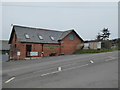
9

Wreford's Lane
Where suburban Exeter meets the countryside.
Image: © Rod Allday
Taken: 1 Nov 2015
0.12 miles
10

Roadside tree, northern edge of Exeter
The road is mapped as both Wrefords Lane and Wrefords Drive, but lane is probably correct.
Image: © Christine Johnstone
Taken: 29 Mar 2014
0.14 miles