IMAGES TAKEN NEAR TO
Thornton Hill, EXETER, EX4 4NS
Introduction
This page details the photographs taken nearby to Thornton Hill, EX4 4NS by members of the Geograph project.
The Geograph project started in 2005 with the aim of publishing, organising and preserving representative images for every square kilometre of Great Britain, Ireland and the Isle of Man.

There are currently over 7.5m images from over14,400 individuals and you can help contribute to the project by visiting https://www.geograph.org.uk
Image Map
Images are licensed for reuse under creativecommons.org/licenses/by-sa/2.0
Notes
- Clicking on the map will re-center to the selected point.
- The higher the marker number, the further away the image location is from the centre of the postcode.
Image Listing (184 Images Found)
Images are licensed for reuse under creativecommons.org/licenses/by-sa/2.0
Image
Details
Distance
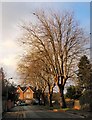
1

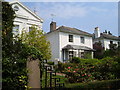
Thornton Hill, Exeter
A pleasant residential road on a south-facing slope above the city centre.
Image: © Derek Harper
Taken: 10 Dec 2008
0.06 miles
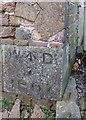
2

Old Boundary Marker by Thornton Hill, Exeter
Estate Boundary Marker - War Department #6 by the UC road, in parish of Exeter (Exeter District), Thornton Hill, at the top bend behind old Horseguards Barracks, in wall.
Inscription reads:-
W^D
No.6B
Surveyed
Milestone Society National ID: DV_EXHG06Wem
Image: © Alan Rosevear
Taken: 25 Mar 2013
0.08 miles
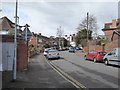
3
Road to Thornton Hill, Exeter
This road links the top ends of Image (at the end) and West Avenue. Behind the trees on the right is a cricket ground.
Image: © Derek Harper
Taken: 10 Dec 2008
0.08 miles
4
West Avenue, Exeter
This residential road takes its name from the wealthy Thornton West family, not the compass direction
Image: © David Smith
Taken: 9 Mar 2016
0.08 miles
5
Old Boundary Marker on the Former Riding School, Horse Guards Barracks
Estate Boundary Marker - War Department by the UC road, in parish of Exeter (Exeter District), end of a drive off Thornton Hill, as a Northeast cornerstone of the Former Riding School for the Horseguards Barracks, behind railings of park.
Inscription reads:-
W ^ D
7
1867
The WD broad arrow has been converted to an O.S. bench mark by addition of a datum line.
The Former Riding School is Grade II listed.
List Entry Number: 1109978 https://historicengland.org.uk/listing/the-list/list-entry/1109978
Surveyed
Milestone Society National ID: DV_EXHG07Wem
Image: © Alan Rosevear
Taken: 2 Apr 2013
0.09 miles
6
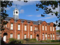
Officer's Quarters, Higher Barracks, Exeter
Another view of Image, showing the clock tower and part of the grassed quadrangle in front.
Image: © Derek Harper
Taken: 3 Oct 2006
0.09 miles
7
Pennsylvania Crescent, Exeter
A row of Regency houses built in the 1820s, north of the city centre just off Pennsylvania Road.
Image: © Derek Harper
Taken: 10 May 2006
0.10 miles
8

Hoopern Lane, Exeter
The name Hoopern comes from the nearby stream. This is a well-used pedestrian route between Exeter city centre and the university campus. This section is supposed to be pedestrian only, but is often used as a cycle route. The wall on the left shows two stages (at least) in construction; that on the right shows several stages of graffiti
Image: © David Smith
Taken: 19 Aug 2015
0.10 miles
9
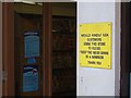
Keep the noise down
A rather unexpected sign at the Co-op in Pennsylvania Road, Exeter. The sign has now gone; obviously the customers have quietened down.
Image: © Derek Harper
Taken: 22 Sep 2005
0.10 miles
10

Officer's Quarters, Higher Barracks, Exeter
Rebuilt in 1880-1 after a fire, but still carrying the original royal coat of arms.
Image: © Derek Harper
Taken: 3 Oct 2006
0.10 miles