IMAGES TAKEN NEAR TO
Hoopern Street, EXETER, EX4 4LU
Introduction
This page details the photographs taken nearby to Hoopern Street, EX4 4LU by members of the Geograph project.
The Geograph project started in 2005 with the aim of publishing, organising and preserving representative images for every square kilometre of Great Britain, Ireland and the Isle of Man.

There are currently over 7.5m images from over14,400 individuals and you can help contribute to the project by visiting https://www.geograph.org.uk
Image Map
Images are licensed for reuse under creativecommons.org/licenses/by-sa/2.0
Notes
- Clicking on the map will re-center to the selected point.
- The higher the marker number, the further away the image location is from the centre of the postcode.
Image Listing (279 Images Found)
Images are licensed for reuse under creativecommons.org/licenses/by-sa/2.0
Image
Details
Distance
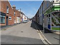
3

Hoopern Street, Exeter
Named after the valley it leads towards, and seen from Howell Road. The terrace on the right is prodigiously long - 45 properties. A cheerfully-painted car in the foreground.
Image: © Derek Harper
Taken: 3 Feb 2009
0.05 miles

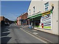
7

King Stephen Nursery mosaic, Blackall Road, Exeter
Image: © David Smith
Taken: 23 Apr 2020
0.07 miles
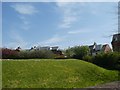
8
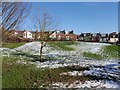
Danes Castle, Exeter
This circular structure was thought to be the remains of a castle built by the Danes when they had Exeter under siege in 1003. In 1993 the castle was found to have been built by King Stephen in 1136. For more information, see David Cornforth’s site at http://www.exetermemories.co.uk/EM/_places/danes.php , from which this information is taken.
In spite of the fact that it owes its origins to the civil war of 1136-47, the earthwork still bears the name "Danes Castle". Its shape is handily picked out by the partly-melted snow that has fallen the previous day.
Image: © Derek Harper
Taken: 3 Feb 2009
0.07 miles
9
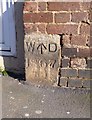
Old Boundary Marker by Howell Road, Exeter
War Department Boundary Marker #1, by Howell Road, in parish of Exeter (Exeter District), No. 2 Howell Road, as a cornerstone to right of door, in wall.
Inscription reads:- : : W ^ D / 1867 / No 1 :
Surveyed
Milestone Society National ID: DV_EXHG01Wem.
Image: © Alan Rosevear
Taken: 2 Apr 2013
0.07 miles
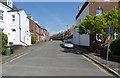
10

Houses on Howell Road, Exeter
An attractive pair of semi-detached houses facing Exeter Prison and beside Danes Castle.
Image: © Derek Harper
Taken: 6 Nov 2006
0.07 miles