IMAGES TAKEN NEAR TO
Velwell Road, EXETER, EX4 4LE
Introduction
This page details the photographs taken nearby to Velwell Road, EX4 4LE by members of the Geograph project.
The Geograph project started in 2005 with the aim of publishing, organising and preserving representative images for every square kilometre of Great Britain, Ireland and the Isle of Man.

There are currently over 7.5m images from over14,400 individuals and you can help contribute to the project by visiting https://www.geograph.org.uk
Image Map
Images are licensed for reuse under creativecommons.org/licenses/by-sa/2.0
Notes
- Clicking on the map will re-center to the selected point.
- The higher the marker number, the further away the image location is from the centre of the postcode.
Image Listing (328 Images Found)
Images are licensed for reuse under creativecommons.org/licenses/by-sa/2.0
Image
Details
Distance
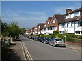
1
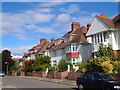
Velwell Road, Exeter
Up-market semi-detached houses close to the city centre.
Image: © Derek Harper
Taken: 3 Oct 2006
0.01 miles

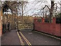
3
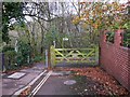
Gate to footpath at the end of Velwell Road
Little has changed since the earlier submission at http://www.geograph.org.uk/photo/1079309 but there is a new inspection cover in the pavement.
Image: © Shazz
Taken: 18 Nov 2011
0.03 miles
4
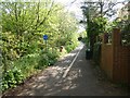
Cycle- and foot-path along the edge of Taddiforde Valley, Exeter
Image: © David Smith
Taken: 23 Apr 2020
0.04 miles
5
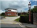
Danes Castle Community Fire Station, Exeter
Image: © Chris Allen
Taken: 6 Jul 2014
0.04 miles
6
Corner of Velwell Road, Exeter
A spur from the right-angled bend in Velwell Road leads to this gate and Exeter Footpath 40, which runs along the edge of the lower Hoopern valley.
Image: © Derek Harper
Taken: 10 Dec 2008
0.04 miles
7

Destroyed benchmark on wall of #26 Velwell Road
The bricks which had the Ordnance Survey cut mark benchmark which is described on the Bench Mark Database at http://www.bench-marks.org.uk/bm40255 have been reused when the wall was rebuilt. The brick with the datum cut and top of the arrows is seen inverted on the fourth brick above ground, and the bottom of the arrows on a brick in the 15th course above ground.
Image: © Roger Templeman
Taken: 19 Nov 2011
0.04 miles
8
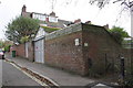
Side wall of #26 Velwell Road and rear footpath
There was an OS benchmark Image on the east face of the wall at the corner. The constituent bricks are now on the north face (by the footpath gatepost)
Image: © Roger Templeman
Taken: 19 Nov 2011
0.04 miles
9
Velwell Road, Exeter
Semi-detached houses with their gardens on the opposite side of the road, as they back onto the valley of Taddiforde Stream
Image: © David Smith
Taken: 23 Apr 2020
0.04 miles
10

Exeter fire station
Exeter fire station, Howell Road, Exeter is station number 32 of the Devon Fire & Rescue Service.
Image: © Kevin Hale
Taken: 3 Sep 2006
0.04 miles