IMAGES TAKEN NEAR TO
Blackall Road, EXETER, EX4 4HD
Introduction
This page details the photographs taken nearby to Blackall Road, EX4 4HD by members of the Geograph project.
The Geograph project started in 2005 with the aim of publishing, organising and preserving representative images for every square kilometre of Great Britain, Ireland and the Isle of Man.

There are currently over 7.5m images from over14,400 individuals and you can help contribute to the project by visiting https://www.geograph.org.uk
Image Map
Images are licensed for reuse under creativecommons.org/licenses/by-sa/2.0
Notes
- Clicking on the map will re-center to the selected point.
- The higher the marker number, the further away the image location is from the centre of the postcode.
Image Listing (357 Images Found)
Images are licensed for reuse under creativecommons.org/licenses/by-sa/2.0
Image
Details
Distance
1
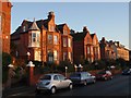
Blackall Road, Exeter
Brick houses reddened still further by the rising sun, on the northwest side of the road between Howell Road and Thornton Hill.
Image: © Derek Harper
Taken: 18 Nov 2008
0.01 miles
2
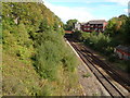
Railway line from Howell Road
The line from Exeter Central to St James' Park station, seen from the Howell Road bridge, with the bridge carrying Longbrook Street visible. On the left, the cutting below Blackall Road Image
Image: © Derek Harper
Taken: 3 Oct 2006
0.02 miles
3
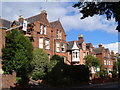
Blackall Road, Exeter
The northern side of the eastern part of the road - a little more up-market than Image, with decorative brickwork in the gables, and a jettied turret beyond the Raffles Hotel - again seen from the crossroads with Howell Road. Housing only occupies the northern side of Blackall Road; to the south the ground drops away down the side of a cutting to the Exeter-Axminster railway line. Blackall Road is named after Offspring Blackall, Bishop of Exeter from 1708-16.
Image: © Derek Harper
Taken: 3 Oct 2006
0.03 miles
4
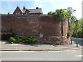
Wall with boundary marker for Higher Barracks, Exeter
The barracks extended to the left of the marker, fronting onto Howell Road
Image: © David Smith
Taken: 23 Apr 2020
0.04 miles
5

Ex L.S.W.R main line east of Exeter Central Station
Looking east from the overbridge at Howell Road, Exeter, the bridge carrying Longbrook Street and what appear to be disused platforms form the distant aspect.
Image: © Tim Marshall
Taken: 8 Sep 2012
0.04 miles
6
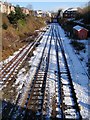
Snow on the tracks
The railway line to London Waterloo after leaving Exeter Central, seen from the Howell Road bridge. The next bridge carries Pennsylvania Road.
Image: © Derek Harper
Taken: 3 Feb 2009
0.04 miles
7
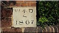
Old Boundary Marker by Blackall Road, Exeter
Estate Boundary Marker - War Department, by the UC road, in parish of Exeter (Exeter District), junction of Howell Road with Blackall Road, in brick boundary wall.
Inscription reads:-
W ^ D
1867
Surveyed
Milestone Society National ID: DV_EXHG08Wem
Image: © Milestone Society
Taken: Unknown
0.04 miles
8
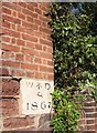
Boundary stone, Exeter
This stone is in a wall on Blackall Road, immediately east of the junction with Howell Road. This point is the southeast corner of the Higher, or Cavalry Barracks that was built on a large area north of the prison in 1794, in the face of the threat from France. Buildings still survive, such as Image Is it simply a boundary stone? And is 1867 a date?
See also Image
Image: © Derek Harper
Taken: 27 Feb 2008
0.05 miles
9
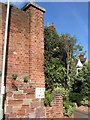
Boundary stone, Exeter
Another view of Image, placing it in a little more context.
Image: © Derek Harper
Taken: 27 Feb 2008
0.05 miles
10

Approaching Exeter Central
A Waterloo to Exeter St David's service approaches Exeter Central. Taken off the quiet road bridge.
Image: © roger geach
Taken: 20 Jul 1991
0.05 miles