IMAGES TAKEN NEAR TO
Dinham Mews, EXETER, EX4 4EH
Introduction
This page details the photographs taken nearby to Dinham Mews, EX4 4EH by members of the Geograph project.
The Geograph project started in 2005 with the aim of publishing, organising and preserving representative images for every square kilometre of Great Britain, Ireland and the Isle of Man.

There are currently over 7.5m images from over14,400 individuals and you can help contribute to the project by visiting https://www.geograph.org.uk
Image Map
Images are licensed for reuse under creativecommons.org/licenses/by-sa/2.0
Notes
- Clicking on the map will re-center to the selected point.
- The higher the marker number, the further away the image location is from the centre of the postcode.
Image Listing (973 Images Found)
Images are licensed for reuse under creativecommons.org/licenses/by-sa/2.0
Image
Details
Distance
1
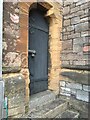
Door of St Michael and All Angels
Cut mark on right hand side near bottom hinge very eroded
https://www.bench-marks.org.uk/bm74475
Image: © thejackrustles
Taken: 18 Jun 2021
0.00 miles
2
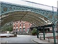
The Iron Bridge, Exeter
This is part of a remarkable viaduct that crosses a valley to what, when it was constructed in 1834, must have been a high-class residential area.
Image: © Humphrey Bolton
Taken: 5 Apr 2010
0.00 miles
3
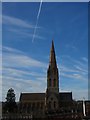
St Michael's church, Exeter
Image: © Derek Harper
Taken: 19 Nov 2008
0.02 miles
4
St Michael's church, Exeter
Another view of the very striking church - see also Image, Image, Image among others. Like the first, this is from St Bartholomew's Lower Cemetery, with Dinham Crescent in front.
Image: © Derek Harper
Taken: 19 Nov 2008
0.02 miles
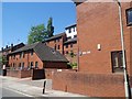
6
Exeter: towards Mount Dinham
The 19th century church of St Michael and All Angels dominates the skyline. Looking west from the Iron Bridge, near the site of Exeter’s North Gate, demolished in 1769
Image: © Martin Bodman
Taken: 14 Mar 2007
0.02 miles
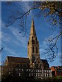
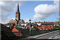
7
St Michael's church, Exeter
See Image This image shows the Italian restaurant in the former malthouse, with Bartholomew Street in the foreground. The church stands on Mount Dinham, beyond the valley containing Exe Street. Taken from the top of Image
Image: © Derek Harper
Taken: 26 Mar 2007
0.02 miles
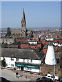
8
St Michael & All Angels, Exeter
Viewed from the Guildhall car park.
Image: © Bill Boaden
Taken: 29 Jun 2011
0.02 miles
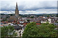
9
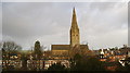
St Michael and All Angels Church, Exeter
The church was built between 1865 and 1868 and apparently possesses the highest spire west of Salisbury at 70 m (230 ft): http://www.exetermemories.co.uk/em/_churches/mtdinham.php
Image: © Chris Holifield
Taken: 6 Jan 2014
0.02 miles
10

St Michael and All Angels, Exeter
Looking west from the Iron Bridge.
Image: © Christine Johnstone
Taken: 29 Mar 2014
0.02 miles