IMAGES TAKEN NEAR TO
St. Davids Hill, EXETER, EX4 4BB
Introduction
This page details the photographs taken nearby to St. Davids Hill, EX4 4BB by members of the Geograph project.
The Geograph project started in 2005 with the aim of publishing, organising and preserving representative images for every square kilometre of Great Britain, Ireland and the Isle of Man.

There are currently over 7.5m images from over14,400 individuals and you can help contribute to the project by visiting https://www.geograph.org.uk
Image Map
Images are licensed for reuse under creativecommons.org/licenses/by-sa/2.0
Notes
- Clicking on the map will re-center to the selected point.
- The higher the marker number, the further away the image location is from the centre of the postcode.
Image Listing (631 Images Found)
Images are licensed for reuse under creativecommons.org/licenses/by-sa/2.0
Image
Details
Distance
1
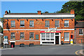
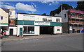
Jolly Porter
Jolly Porter public House in Exeter
Image: © Wayland Smith
Taken: 25 Jun 2011
0.01 miles
2
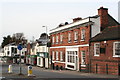
The Jolly Porter public house on St David's Hill
Operating originally as the Elmfield Hotel from the mid C19th, it was renamed The Jolly Porter in 1957. Apparently Paul Simon played at the Exeter Folk Club here in 1965.
Image: © Rod Allday
Taken: 2 Mar 2010
0.01 miles
3
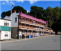
Jolly Porter under scaffolding, Exeter
Viewed across St David's Hill in late August 2016.
A May 2015 Google Earth Street View shows a derelict Jolly Porter pub here.
Image: © Jaggery
Taken: 26 Aug 2016
0.01 miles
4
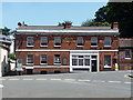
Former pub, St David's Hill, Exeter
The Jolly Porter was an early/mid C19th pub, originally the Elmfield Hotel (exetermemories.co.uk). Grade II listed.
It closed in 2014, but may have since re-opened as a Chinese restaurant.
Image: © Stephen Richards
Taken: 20 Jun 2014
0.01 miles
5
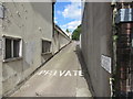
Windsor Close, Exeter
Narrow private road near Exeter St Davids railway station.
The notice on the right shows NO PARKING PLEASE KEEP CLEAR.
Image: © Jaggery
Taken: 26 Aug 2016
0.01 miles
6

The Jolly Porter, St Davids Hill
There is an OS benchmark Image on the front left corner of the pub under the road name signs
Image: © Roger Templeman
Taken: 19 Nov 2011
0.02 miles
7
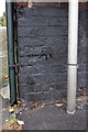
Benchmark on The Jolly Porter, St Davids Hill
Ordnance Survey cut mark benchmark described on the Bench Mark Database at http://www.bench-marks.org.uk/bm40251
Image: © Roger Templeman
Taken: 19 Nov 2011
0.02 miles
8
Greenslades Service Garage, Exeter
At the bottom of St Davids Hill, near Exeter St Davids railway station.
Image: © Jaggery
Taken: 26 Aug 2016
0.02 miles
9
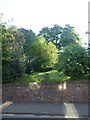
Morning sunlight and trees at The Imperial, Exeter
The old stone wall dates from when the grounds were part of a grand suburban house
Image: © David Smith
Taken: 18 May 2020
0.02 miles
10
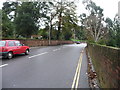
Exeter : St David's Hill
An uphill road which shares the name of the nearby train station.
Image: © Lewis Clarke
Taken: 5 Dec 2009
0.02 miles