IMAGES TAKEN NEAR TO
North Bridge Place, EXETER, EX4 3RE
Introduction
This page details the photographs taken nearby to North Bridge Place, EX4 3RE by members of the Geograph project.
The Geograph project started in 2005 with the aim of publishing, organising and preserving representative images for every square kilometre of Great Britain, Ireland and the Isle of Man.

There are currently over 7.5m images from over14,400 individuals and you can help contribute to the project by visiting https://www.geograph.org.uk
Image Map
Images are licensed for reuse under creativecommons.org/licenses/by-sa/2.0
Notes
- Clicking on the map will re-center to the selected point.
- The higher the marker number, the further away the image location is from the centre of the postcode.
Image Listing (882 Images Found)
Images are licensed for reuse under creativecommons.org/licenses/by-sa/2.0
Image
Details
Distance
1
Ghost sign on the wall, St David
The text: "1860 The West of England" is just legible, and the building housed The West of England School for Young People with Little or No Sight; the building was extended in 1860. The ghost signs on the next two blocks are harder to read
Image: © David Smith
Taken: 8 Sep 2018
0.00 miles
2
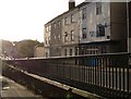
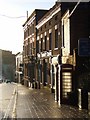
North Bridge Inn, Exeter
St David's Hill divides into the Iron Bridge (beyond the railing and visible left background) and Lower North Street (left foreground). The alley to the right of the pub is North Bridge Place.
Image: © Derek Harper
Taken: 31 Oct 2006
0.01 miles
3
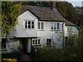
30-33 Lower North Street, Exeter
One of the more unusual sights close to the city centre, and right beside the Iron Bridge. This appears to be a C17 rural house, complete with projecting jetty porch with wooden supports http://list.english-heritage.org.uk/resultsingle.aspx?uid=1273710&searchtype=mapsearch . It is now divided into three.
Image: © Derek Harper
Taken: 31 Oct 2006
0.01 miles
4

Benchmark on the Community Centre, St Davids Hill
Ordnance Survey cut mark benchmark described on the Bench Mark Database at http://www.bench-marks.org.uk/bm40241
Image: © Roger Templeman
Taken: 19 Nov 2011
0.02 miles
5

The Community Centre during refurbishment
There is an OS benchmark Image on the front of the building
Image: © Roger Templeman
Taken: 19 Nov 2011
0.02 miles
6
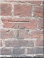
Ordnance Survey Cut Mark
This OS cut mark can be found on the SW side of St David's Hill. It marks a point 31.3883m above mean sea level.
Image: © Adrian Dust
Taken: 22 Mar 2016
0.02 miles
7

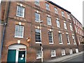
17 St David's Hill, Exeter
The core is a good five-bay Georgian house, to which over the following century or so were added the tall range to the left and a lower range to the right. Grade II listed.
The whole building now houses Exeter Community Centre. Facing the threat of it being sold to developers, a local trust persuaded Devon County Council to transfer ownership in 2003.
Image: © Stephen Richards
Taken: 19 Jun 2014
0.02 miles
8
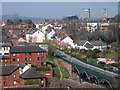
Lower North Street and Iron Bridge from Mary Arches car park, Exeter
From an upper floor of the car park, a view across Image and Lower North Street leading up to St David's Hill, with Image (the rural-looking building) placed in context on the right. Above are the towers of Image and Image Below left is some of the modern housing seen in Image
Image: © Derek Harper
Taken: 26 Mar 2007
0.02 miles
9
Exeter Community Centre
Image: © Derek Harper
Taken: 4 Feb 2008
0.03 miles
10
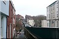
The Iron Bridge
Looking south-east towards North Gate across the iron bridge.
Image: © Graham Horn
Taken: 22 Jan 2009
0.03 miles