IMAGES TAKEN NEAR TO
Fore Street, EXETER, EX4 3JB
Introduction
This page details the photographs taken nearby to Fore Street, EX4 3JB by members of the Geograph project.
The Geograph project started in 2005 with the aim of publishing, organising and preserving representative images for every square kilometre of Great Britain, Ireland and the Isle of Man.

There are currently over 7.5m images from over14,400 individuals and you can help contribute to the project by visiting https://www.geograph.org.uk
Image Map
Images are licensed for reuse under creativecommons.org/licenses/by-sa/2.0
Notes
- Clicking on the map will re-center to the selected point.
- The higher the marker number, the further away the image location is from the centre of the postcode.
Image Listing (1942 Images Found)
Images are licensed for reuse under creativecommons.org/licenses/by-sa/2.0
Image
Details
Distance
1

The upper portion of Fore Street, Exeter
The building housing the further facade of the Exonian was formerly a hotel, then an early picture-house
Image: © David Smith
Taken: 8 Feb 2022
0.00 miles
2
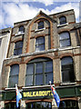
Walkabout in Exeter
One example of the eclectic mix of architectural styles in Fore Street.
Image: © Neil Owen
Taken: 20 Aug 2014
0.01 miles
3
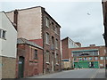
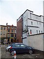
Former warehouse, Smythen Street
This building caught my eye. The modern building beyond is less appealing.
Image: © Chris Allen
Taken: 14 Apr 2017
0.01 miles
4
Stone building with brick buttresses, Smythen Street, Exeter
The stone construction uses locally quarried stone; this area was bombed in 1942, and this is a survivor of that event.
Image: © David Smith
Taken: 22 Dec 2022
0.01 miles
5
Private car park, Market Street, Exeter
Seen from the first floor of Exeter Corn Exchange. The mural was painted when the shop on the corner sold surfing equipment and clothing; now it is a charity shop
Image: © David Smith
Taken: 9 Sep 2013
0.01 miles
6

Private car park and mural, Market Street, Exeter
The mural was painted on the blank rear wall of a shop which sold surfing equipment and clothing; now it is a charity shop
Image: © David Smith
Taken: 9 Sep 2013
0.01 miles
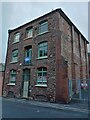
7
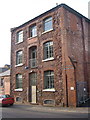
Bathurst House, Smythen Street, Exeter
A little below the junction with Market Street. This building of red sandstone and brick may have been the Wilcocks & Wilcocks warehouse listed in Kelly's 1897 directory.
Image: © Derek Harper
Taken: 29 Nov 2006
0.02 miles
8
Weeds in the drain, Fore Street, Exeter
A buddleia has become established in the drain at the side of this property in Fore Street. Less easy to see, a further weed is established on the front of the roof. This is the view from the car park of the Mint Methodist Church, looking across the road to the Australian-style bar.
Image: © David Smith
Taken: 9 Nov 2013
0.02 miles
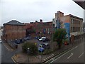
9

City Arcade, Exeter
This small modern arcade, a little away from the main shopping hub of the city, links Fore Street to Smythen Street; the Smythen Street car park is beyond the hedge.
Image: © Derek Harper
Taken: 26 Sep 2006
0.02 miles
10

Fore Street, Exeter
Fore Street, seen here from opposite Image, drops steeply from the city centre towards the Exe, and contains some of Exeter's oldest buildings, especially on this northern side. The Mint Tavern, on the corner of the lane simply called "The Mint", has only been a pub in relatively recent times.
Image: © Derek Harper
Taken: 13 Mar 2008
0.02 miles