IMAGES TAKEN NEAR TO
Kinnerton Way, EXETER, EX4 2PP
Introduction
This page details the photographs taken nearby to Kinnerton Way, EX4 2PP by members of the Geograph project.
The Geograph project started in 2005 with the aim of publishing, organising and preserving representative images for every square kilometre of Great Britain, Ireland and the Isle of Man.

There are currently over 7.5m images from over14,400 individuals and you can help contribute to the project by visiting https://www.geograph.org.uk
Image Map
Images are licensed for reuse under creativecommons.org/licenses/by-sa/2.0
Notes
- Clicking on the map will re-center to the selected point.
- The higher the marker number, the further away the image location is from the centre of the postcode.
Image Listing (42 Images Found)
Images are licensed for reuse under creativecommons.org/licenses/by-sa/2.0
Image
Details
Distance
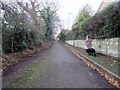
1
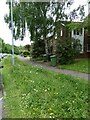
Verge with wild flowers, Kinnerton Way, Exwick
Image: © David Smith
Taken: 25 May 2022
0.03 miles
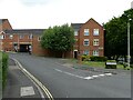
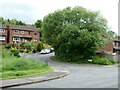
2

Garage for houses in Kinnerton Way, Exwick
Image: © David Smith
Taken: 25 May 2022
0.03 miles
4
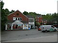
Supermarket and community centre, Exwick
Image: © David Smith
Taken: 25 May 2022
0.06 miles
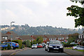
5
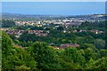
Exeter : Whitycombe Way Valley Park
Looking across the commanding views of Exeter.
Image: © Lewis Clarke
Taken: 26 Jun 2022
0.09 miles
6
Burrator Drive, Exwick
Spread out across the skyline across the Exe is the western edge of Exeter University's Streatham campus. Left to right Image catching the sun, Image, Image, Image, Image
Image: © Pierre Terre
Taken: 21 Sep 2008
0.09 miles
7
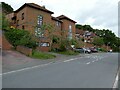
Bus stop and block of houses, Farm Hill, Exwick
Image: © David Smith
Taken: 25 May 2022
0.11 miles
9
Haytor Drive, Exwick
Running north from Higher Exwick Hill.
Image: © Christine Johnstone
Taken: 29 Mar 2014
0.12 miles
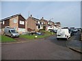
10
Higher Exwick Hill
Leading to Gloucester Road with no vehicular access. Hidden to the left is the site of the demolished Exwick Middle School which is now subject to a planning application for residential development.
Image: © Peter Holmes
Taken: 9 Dec 2017
0.13 miles