IMAGES TAKEN NEAR TO
Whitestone, EXETER, EX4 2HW
Introduction
This page details the photographs taken nearby to EX4 2HW by members of the Geograph project.
The Geograph project started in 2005 with the aim of publishing, organising and preserving representative images for every square kilometre of Great Britain, Ireland and the Isle of Man.

There are currently over 7.5m images from over14,400 individuals and you can help contribute to the project by visiting https://www.geograph.org.uk
Image Map
Images are licensed for reuse under creativecommons.org/licenses/by-sa/2.0
Notes
- Clicking on the map will re-center to the selected point.
- The higher the marker number, the further away the image location is from the centre of the postcode.
Image Listing (2 Images Found)
Images are licensed for reuse under creativecommons.org/licenses/by-sa/2.0
Image
Details
Distance
1
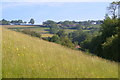
Higher Hare
A distant view of the farm on Folley Lane from across a grassy field by Hare Lane; the two lanes join on the hillside to the left.
Image: © Derek Harper
Taken: 6 Jun 2006
0.14 miles
2

Road passes Pound Down View House
Image: © Sarah Charlesworth
Taken: 4 Nov 2009
0.23 miles