IMAGES TAKEN NEAR TO
Whitestone, EXETER, EX4 2HJ
Introduction
This page details the photographs taken nearby to EX4 2HJ by members of the Geograph project.
The Geograph project started in 2005 with the aim of publishing, organising and preserving representative images for every square kilometre of Great Britain, Ireland and the Isle of Man.

There are currently over 7.5m images from over14,400 individuals and you can help contribute to the project by visiting https://www.geograph.org.uk
Image Map
Images are licensed for reuse under creativecommons.org/licenses/by-sa/2.0
Notes
- Clicking on the map will re-center to the selected point.
- The higher the marker number, the further away the image location is from the centre of the postcode.
Image Listing (4 Images Found)
Images are licensed for reuse under creativecommons.org/licenses/by-sa/2.0
Image
Details
Distance
2

Heath Lane
Looking up the hill towards Heath Cross.
Image: © Rod Allday
Taken: 7 Apr 2011
0.16 miles
3

Fields in Heath Lane
The house is Heath Cross Cottage.
Image: © Rod Allday
Taken: 7 Apr 2011
0.18 miles
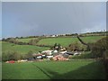
4

Fields to the north of Pathfinder Village
Image: © Sarah Charlesworth
Taken: 4 Nov 2009
0.19 miles