IMAGES TAKEN NEAR TO
Antonine Crescent, EXETER, EX4 1SP
Introduction
This page details the photographs taken nearby to Antonine Crescent, EX4 1SP by members of the Geograph project.
The Geograph project started in 2005 with the aim of publishing, organising and preserving representative images for every square kilometre of Great Britain, Ireland and the Isle of Man.

There are currently over 7.5m images from over14,400 individuals and you can help contribute to the project by visiting https://www.geograph.org.uk
Image Map
Images are licensed for reuse under creativecommons.org/licenses/by-sa/2.0
Notes
- Clicking on the map will re-center to the selected point.
- The higher the marker number, the further away the image location is from the centre of the postcode.
Image Listing (19 Images Found)
Images are licensed for reuse under creativecommons.org/licenses/by-sa/2.0
Image
Details
Distance
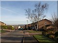
1

Antonine Crescent, Redhills, Exeter
A residential road, adjacent to Hadrian Drive - two roads named after Roman builders of walls
Image: © David Smith
Taken: 7 Aug 2016
0.02 miles
2
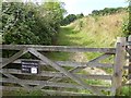
Entrance to Barley Farm Nature Reserve, Antonine Crescent, Exeter
Image: © David Smith
Taken: 7 Aug 2016
0.03 miles
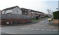
3
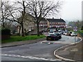
Antonine Crescent, Exeter
And that's Hadrian Drive going off to the left. Not quite sure why those ancient walls should be celebrated in this modern housing estate. Ahead is the T-junction with Redhills.
Image: © Derek Harper
Taken: 2 Mar 2010
0.04 miles
4
Antonine Crescent leading to Hadrian Drive
A reminder of Roman walls on the south side of Redhills, Exeter.
Image: © Christine Johnstone
Taken: 29 Mar 2014
0.05 miles
5
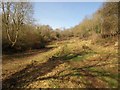
Barley Valley Local Nature Reserve
Looking up the path that runs along the north side of the stream down the valley in Image
Image: © Derek Harper
Taken: 2 Mar 2010
0.08 miles
6
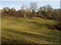
Barley Valley Local Nature Reserve
The scene that you get by following the signpost shown in Image, as the small valley begins to descend Redhills.
Image: © Derek Harper
Taken: 2 Mar 2010
0.14 miles
7
Higher Barley Mount, Exeter
On the south side of Redhills.
Image: © Christine Johnstone
Taken: 29 Mar 2014
0.15 miles
8
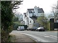
House at the 63 metre spot height, Redhills
On a steep section of the road [1 in 7, or 14%].
Image: © Christine Johnstone
Taken: 29 Mar 2014
0.15 miles
9

Junction of Redhills and Lichfield Road
The footpath has been routed well away from the road on the edge of the Redhills housing estate
Image: © David Smith
Taken: 31 Mar 2011
0.15 miles
10

Ivy-covered trees, Redhills
On a steep section of the road, descending towards Exeter city centre.
Image: © Christine Johnstone
Taken: 29 Mar 2014
0.16 miles