IMAGES TAKEN NEAR TO
Fore Street, BIDEFORD, EX39 6BE
Introduction
This page details the photographs taken nearby to Fore Street, EX39 6BE by members of the Geograph project.
The Geograph project started in 2005 with the aim of publishing, organising and preserving representative images for every square kilometre of Great Britain, Ireland and the Isle of Man.

There are currently over 7.5m images from over14,400 individuals and you can help contribute to the project by visiting https://www.geograph.org.uk
Image Map
Images are licensed for reuse under creativecommons.org/licenses/by-sa/2.0
Notes
- Clicking on the map will re-center to the selected point.
- The higher the marker number, the further away the image location is from the centre of the postcode.
Image Listing (51 Images Found)
Images are licensed for reuse under creativecommons.org/licenses/by-sa/2.0
Image
Details
Distance
1

The Pop In, Hartland
This is a general store, supplying fresh food for the village and surroundings. According to its website, you can buy "Cheese's" here. The Handy Store next door is currently not very handy
Image: © David Smith
Taken: 19 Aug 2013
0.00 miles
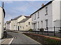
3

A touch of Ireland in West Devon
I echo Derek's comments in his geograph taken 8 years previous to this; Image
The shop still struggles on...
Image: © Jonathan Billinger
Taken: 13 Sep 2015
0.00 miles
4

M O Donnell and Sons
This old shop front is at 41 Fore St. It is no longer used as a shop and there is a hand written note in the window saying
"District Nurse
Come in and Shout"
Image: © Nigel Mykura
Taken: 23 May 2017
0.01 miles
5

Church in the centre of Hartland
Church and war memorial in the centre of Hartland.
Built on the site of the town hall, the chapel of St John is no longer used for worship.
Image: © Philip Halling
Taken: 27 Sep 2009
0.01 miles
6

Hartland village in Devon
This telephoto assisted image shows part of western Hartland seen from a distance of about five hundred metres.
Image]
Image: © Roger D Kidd
Taken: 30 Jun 2015
0.02 miles
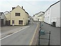
7
Fore Street, Hartland
Looking west along this narrow main street, a one way road.
Image: © Jonathan Billinger
Taken: 13 Sep 2015
0.02 miles
8
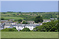
Hartland village in Devon
This telephoto assisted image shows part of western Hartland seen from a distance of about five hundred metres.
Image]
Image: © Roger D Kidd
Taken: 30 Jun 2015
0.02 miles
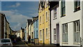
9
Hartland
Fore Street in Hartland, with its raised pavement on the northern side. The junction on the corner is with the lane shown in Image; beyond this point is across the gridline in Image
Image: © Derek Harper
Taken: 24 Jul 2007
0.03 miles
10
Ordnance Survey Cut Mark
This OS cut mark can be found on the old Lloyds Bank building. It marks a point 111.206m above mean sea level.
Image: © Adrian Dust
Taken: 22 Jan 2018
0.03 miles