IMAGES TAKEN NEAR TO
Hartland, BIDEFORD, EX39 6AL
Introduction
This page details the photographs taken nearby to EX39 6AL by members of the Geograph project.
The Geograph project started in 2005 with the aim of publishing, organising and preserving representative images for every square kilometre of Great Britain, Ireland and the Isle of Man.

There are currently over 7.5m images from over14,400 individuals and you can help contribute to the project by visiting https://www.geograph.org.uk
Image Map (Loading...)


Getting Data...Please wait
Leaflet Map data © OpenStreetMap
Images are licensed for reuse under creativecommons.org/licenses/by-sa/2.0
Notes
- Clicking on the map will re-center to the selected point.
- The higher the marker number, the further away the image location is from the centre of the postcode.
Image Listing (3 Images Found)
Images are licensed for reuse under creativecommons.org/licenses/by-sa/2.0
Image
Details
Distance
1

Direction Sign - Signpost by the B3248, Mettaford Cross
Flat pyramid finial - 4 arms; Devon simple wood by the B3248, in parish of Hartland (Torridge District), Mettaford Cross.
Surveyed
Milestone Society National ID: DV_SS2724
Image: © Tim Jenkinson
Taken: 4 Jul 2009
0.05 miles
2
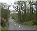
Lane heading into Rosedown
This is one of the main routes, off the main road, to Hartland Point.
Image: © Fernweh
Taken: 3 Aug 2014
0.10 miles