IMAGES TAKEN NEAR TO
Higher Clovelly, BIDEFORD, EX39 5SX
Introduction
This page details the photographs taken nearby to EX39 5SX by members of the Geograph project.
The Geograph project started in 2005 with the aim of publishing, organising and preserving representative images for every square kilometre of Great Britain, Ireland and the Isle of Man.

There are currently over 7.5m images from over14,400 individuals and you can help contribute to the project by visiting https://www.geograph.org.uk
Image Map
Images are licensed for reuse under creativecommons.org/licenses/by-sa/2.0
Notes
- Clicking on the map will re-center to the selected point.
- The higher the marker number, the further away the image location is from the centre of the postcode.
Image Listing (7 Images Found)
Images are licensed for reuse under creativecommons.org/licenses/by-sa/2.0
Image
Details
Distance
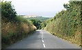
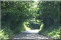
1

Clovelly : Higher Clovelly - B3237
Looking along the road.
Image: © Lewis Clarke
Taken: 6 Aug 2023
0.11 miles
3
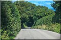
Clovelly : B3237
Looking along the B3237.
Image: © Lewis Clarke
Taken: 6 Aug 2023
0.21 miles
4
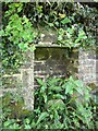
Well head, Wrinkleberry
By the lane and just above the houses in the hamlet.
Image: © Derek Harper
Taken: 12 Aug 2013
0.22 miles
5

Clovelly : Higher Clovelly - Houses
Houses seen alongside the B3237.
Image: © Lewis Clarke
Taken: 6 Aug 2023
0.22 miles
6
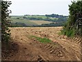
Field near Hugglepit
A gateway and harvested field on an interfluve southwest of Clovelly. Beyond, the field drops to the wooded valley of the Mouthmill stream, climbing beyond into Image, with Higher and Nether Velly farms.
Image: © Derek Harper
Taken: 25 Sep 2008
0.23 miles
7
Clovelly : B3237
Looking along the B3237.
Image: © Lewis Clarke
Taken: 6 Aug 2023
0.25 miles