IMAGES TAKEN NEAR TO
Higher Clovelly, BIDEFORD, EX39 5SH
Introduction
This page details the photographs taken nearby to EX39 5SH by members of the Geograph project.
The Geograph project started in 2005 with the aim of publishing, organising and preserving representative images for every square kilometre of Great Britain, Ireland and the Isle of Man.

There are currently over 7.5m images from over14,400 individuals and you can help contribute to the project by visiting https://www.geograph.org.uk
Image Map
Images are licensed for reuse under creativecommons.org/licenses/by-sa/2.0
Notes
- Clicking on the map will re-center to the selected point.
- The higher the marker number, the further away the image location is from the centre of the postcode.
Image Listing (3 Images Found)
Images are licensed for reuse under creativecommons.org/licenses/by-sa/2.0
Image
Details
Distance
1
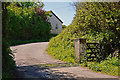
An access road to Westhay Farm,Trew Farm and other premises
Image: © Roger A Smith
Taken: 15 May 2014
0.02 miles
2
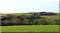
Westhay Farm
In between is a small valley near Clifford.
Image: © Jonathan Billinger
Taken: 6 Feb 2008
0.02 miles
3
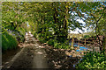
A track which runs between Clifford Mill and Burford
Image: © Roger A Smith
Taken: 15 May 2014
0.11 miles