IMAGES TAKEN NEAR TO
Buckland Brewer, BIDEFORD, EX39 5NL
Introduction
This page details the photographs taken nearby to EX39 5NL by members of the Geograph project.
The Geograph project started in 2005 with the aim of publishing, organising and preserving representative images for every square kilometre of Great Britain, Ireland and the Isle of Man.

There are currently over 7.5m images from over14,400 individuals and you can help contribute to the project by visiting https://www.geograph.org.uk
Image Map
Images are licensed for reuse under creativecommons.org/licenses/by-sa/2.0
Notes
- Clicking on the map will re-center to the selected point.
- The higher the marker number, the further away the image location is from the centre of the postcode.
Image Listing (4 Images Found)
Images are licensed for reuse under creativecommons.org/licenses/by-sa/2.0
Image
Details
Distance
1
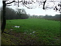
Pastures east of Danesmoor
Viewed from Wrangworthy Cross.
Image: © Jonathan Billinger
Taken: 16 Jan 2008
0.17 miles
2
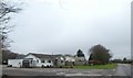
Bungalows at Little Collingsdown
The large apron by the nearer bungalow allows access to a haulage business whose facilities are behind
Image: © David Smith
Taken: 21 Mar 2019
0.18 miles
3
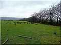
View north of Little Collingsdown
Unimproved pasture land in west Devon.
Image: © Jonathan Billinger
Taken: 16 Jan 2008
0.22 miles
4
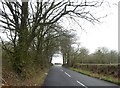
Hedgebank and hedge near Wrangworthy Cross
The crossroads is on the bend in the road
Image: © David Smith
Taken: 21 Mar 2019
0.25 miles