IMAGES TAKEN NEAR TO
Monkleigh, BIDEFORD, EX39 5JS
Introduction
This page details the photographs taken nearby to EX39 5JS by members of the Geograph project.
The Geograph project started in 2005 with the aim of publishing, organising and preserving representative images for every square kilometre of Great Britain, Ireland and the Isle of Man.

There are currently over 7.5m images from over14,400 individuals and you can help contribute to the project by visiting https://www.geograph.org.uk
Image Map (Loading...)


Getting Data...Please wait
Leaflet Map data © OpenStreetMap
Images are licensed for reuse under creativecommons.org/licenses/by-sa/2.0
Notes
- Clicking on the map will re-center to the selected point.
- The higher the marker number, the further away the image location is from the centre of the postcode.
Image Listing (16 Images Found)
Images are licensed for reuse under creativecommons.org/licenses/by-sa/2.0
Image
Details
Distance
1
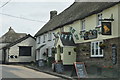
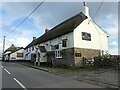
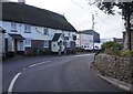
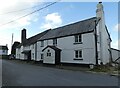
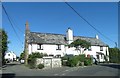
Monkleigh : The Bell Inn
The Bell Inn seen on the A388 heading through Monkleigh.
Image: © Lewis Clarke
Taken: 17 Jul 2014
0.02 miles
7
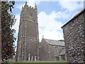
Monkleigh Church
Some of my BLIGHT ancestors came from here.
Image: © Stephen Bashford
Taken: Unknown
0.17 miles
9
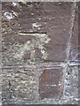
Ordnance Survey Cut Mark
This OS cut mark can be found on the NW angle of the porch of St George's Church. It marks a point 122.740m above mean sea level.
Image: © Adrian Dust
Taken: 18 Oct 2015
0.19 miles
10
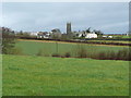
Monkleigh - across the fields
Church tower and some houses viewed from the south.
Image: © Jonathan Billinger
Taken: 16 Jan 2008
0.19 miles