IMAGES TAKEN NEAR TO
Monkleigh, BIDEFORD, EX39 5JR
Introduction
This page details the photographs taken nearby to EX39 5JR by members of the Geograph project.
The Geograph project started in 2005 with the aim of publishing, organising and preserving representative images for every square kilometre of Great Britain, Ireland and the Isle of Man.

There are currently over 7.5m images from over14,400 individuals and you can help contribute to the project by visiting https://www.geograph.org.uk
Image Map (Loading...)


Getting Data...Please wait
Leaflet Map data © OpenStreetMap
Images are licensed for reuse under creativecommons.org/licenses/by-sa/2.0
Notes
- Clicking on the map will re-center to the selected point.
- The higher the marker number, the further away the image location is from the centre of the postcode.
Image Listing (13 Images Found)
Images are licensed for reuse under creativecommons.org/licenses/by-sa/2.0
Image
Details
Distance
5
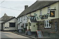
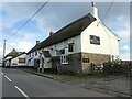
Monkleigh : The Bell Inn
The Bell Inn seen on the A388 heading through Monkleigh.
Image: © Lewis Clarke
Taken: 17 Jul 2014
0.15 miles
6

Pasture land near Petticombe Manor 2
Photographed almost at grass level because of the deep-set lane.
Image: © Jonathan Billinger
Taken: 7 Oct 2008
0.15 miles
10

Entrance to Petticombe Manor
Looks a bit past its best
Image: © Geoff Gartside
Taken: 30 Sep 2007
0.16 miles