IMAGES TAKEN NEAR TO
EX39 5FP
Introduction
This page details the photographs taken nearby to EX39 5FP by members of the Geograph project.
The Geograph project started in 2005 with the aim of publishing, organising and preserving representative images for every square kilometre of Great Britain, Ireland and the Isle of Man.

There are currently over 7.5m images from over14,400 individuals and you can help contribute to the project by visiting https://www.geograph.org.uk
Image Map (Loading...)


Getting Data...Please wait
Leaflet Map data © OpenStreetMap
Images are licensed for reuse under creativecommons.org/licenses/by-sa/2.0
Notes
- Clicking on the map will re-center to the selected point.
- The higher the marker number, the further away the image location is from the centre of the postcode.
Image Listing (45 Images Found)
Images are licensed for reuse under creativecommons.org/licenses/by-sa/2.0
Image
Details
Distance
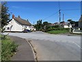
1

Footpath to Easter View from Parkham
Easter View is a house marked on the OS maps from the 1950s onwards
Image: © David Smith
Taken: 28 Jul 2021
0.03 miles
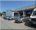
3

The garage at Parkham
On the gable, there is the support for the signboard of the former fuel sold here (probably Esso from the shape)
Image: © David Smith
Taken: 28 Jul 2021
0.14 miles


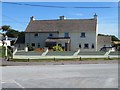
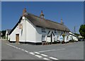
8
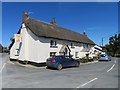
The Bell Inn
Not much of a pub garden but the food did not disappoint.
Image: © Fernweh
Taken: 15 Aug 2016
0.14 miles