IMAGES TAKEN NEAR TO
Weare Giffard, BIDEFORD, EX39 4QU
Introduction
This page details the photographs taken nearby to EX39 4QU by members of the Geograph project.
The Geograph project started in 2005 with the aim of publishing, organising and preserving representative images for every square kilometre of Great Britain, Ireland and the Isle of Man.

There are currently over 7.5m images from over14,400 individuals and you can help contribute to the project by visiting https://www.geograph.org.uk
Image Map (Loading...)


Getting Data...Please wait
Leaflet Map data © OpenStreetMap
Images are licensed for reuse under creativecommons.org/licenses/by-sa/2.0
Notes
- Clicking on the map will re-center to the selected point.
- The higher the marker number, the further away the image location is from the centre of the postcode.
Image Listing (13 Images Found)
Images are licensed for reuse under creativecommons.org/licenses/by-sa/2.0
Image
Details
Distance
3
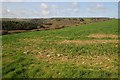
Above the Torridge valley
View across the Torridge valley near Weare Giffard.
Image: © Philip Halling
Taken: 11 Apr 2015
0.06 miles
4
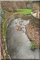
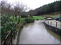
Huntshaw Water
Less water in it than when Image was taken nearly 12 years earlier. This looks upstream from Chope's Bridge at Weare Giffard; Image] looks downstream.
Image: © Derek Harper
Taken: 1 Dec 2019
0.09 miles
5
The Huntshaw River
View east from the bridge at Weare Giffard.
Image: © Jonathan Billinger
Taken: 15 Jan 2008
0.10 miles
6
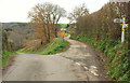
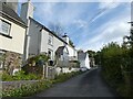
Junction near Weare Giffard
The main lane drops to the left towards the southern end of the village in the Torridge valley; the lane on the right is a route with public access that drops more slowly towards the northern part of the village. Presumably something rather crucial is missing from the speed restriction sign's post, otherwise the implication is that you can drive much faster is you're using the lane for access than if you're using it as a through route. Unfortunately Google's Streetview vehicles travelled at such speed down the lane that the detail is hard to make out. I assume it's not permitted to use it as a shortcut.
Image: © Derek Harper
Taken: 1 Dec 2019
0.10 miles
8

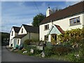
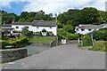
Cottages at Weare Giffard
There's been a lot of rain recently, but nothing like as much as when Image was taken. Centre stage here is the listed Honeysuckle Cottage https://historicengland.org.uk/listing/the-list/list-entry/1326563 .
Image: © Derek Harper
Taken: 1 Dec 2019
0.11 miles
9
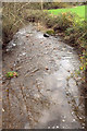
Huntshaw Water
Looking downstream from Chope's Bridge at Weare Giffard; Image] looks upstream. In about 100 metres the stream meets the River Torridge.
Image: © Derek Harper
Taken: 1 Dec 2019
0.12 miles
10

Take the high road at Weare Giffard
The floods of last week have left significant standing water in the valley road to the left. The road to the right climbs the hill towards Cleave.
Image: © Jonathan Billinger
Taken: 15 Jan 2008
0.12 miles