IMAGES TAKEN NEAR TO
Stoney Cross, BIDEFORD, EX39 4PY
Introduction
This page details the photographs taken nearby to EX39 4PY by members of the Geograph project.
The Geograph project started in 2005 with the aim of publishing, organising and preserving representative images for every square kilometre of Great Britain, Ireland and the Isle of Man.

There are currently over 7.5m images from over14,400 individuals and you can help contribute to the project by visiting https://www.geograph.org.uk
Image Map (Loading...)


Getting Data...Please wait
Leaflet Map data © OpenStreetMap
Images are licensed for reuse under creativecommons.org/licenses/by-sa/2.0
Notes
- Clicking on the map will re-center to the selected point.
- The higher the marker number, the further away the image location is from the centre of the postcode.
Image Listing (8 Images Found)
Images are licensed for reuse under creativecommons.org/licenses/by-sa/2.0
Image
Details
Distance
1

Horwood : Grassy Field
A pylon on the hillside.
Image: © Lewis Clarke
Taken: 7 Sep 2021
0.11 miles
2
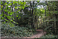
Webbery : Webbery Wood
A track heads through the woods.
Image: © Lewis Clarke
Taken: 7 Sep 2021
0.23 miles
3

Farmland and cottage near Alverdiscott
Farmland and thatched cottage near Alverdiscott.
Image: © Philip Halling
Taken: 11 Apr 2015
0.23 miles
4
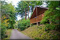
Webbery : Track
A track passing huts from Bulworthy Forest Lodges.
Image: © Lewis Clarke
Taken: 7 Sep 2021
0.24 miles
5
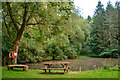
Webbery : Pond
A pond at Webbery Woods.
Image: © Lewis Clarke
Taken: 7 Sep 2021
0.24 miles
6
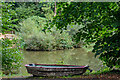
Webbery : Lake
A small lake and a boat in the woods.
Image: © Lewis Clarke
Taken: 7 Sep 2021
0.24 miles
7

Webbery : Track
A track heads through the woods.
Image: © Lewis Clarke
Taken: 7 Sep 2021
0.25 miles
8
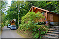
Webbery : Bulworthy Forest Lodges
Bulworthy Forest Lodges is part of our Wanderwood Lodge Holidays Collection, tucked away down a tree-lined drive leading to Bulworthy Forest.
Image: © Lewis Clarke
Taken: 7 Sep 2021
0.25 miles