IMAGES TAKEN NEAR TO
Westleigh, BIDEFORD, EX39 4NR
Introduction
This page details the photographs taken nearby to EX39 4NR by members of the Geograph project.
The Geograph project started in 2005 with the aim of publishing, organising and preserving representative images for every square kilometre of Great Britain, Ireland and the Isle of Man.

There are currently over 7.5m images from over14,400 individuals and you can help contribute to the project by visiting https://www.geograph.org.uk
Image Map
Images are licensed for reuse under creativecommons.org/licenses/by-sa/2.0
Notes
- Clicking on the map will re-center to the selected point.
- The higher the marker number, the further away the image location is from the centre of the postcode.
Image Listing (12 Images Found)
Images are licensed for reuse under creativecommons.org/licenses/by-sa/2.0
Image
Details
Distance
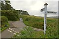
1
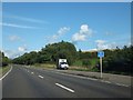
Lay-by for westbound traffic on A39 near Bradavin Bridge
The woods ahead do not appear to be named on maps; Bradavin Bridge is a short way down the valley on the right
Image: © David Smith
Taken: 19 Aug 2013
0.14 miles
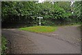
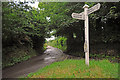
6
Blackgate Cross not far from Westleigh
Image: © Roger A Smith
Taken: 8 Jul 2012
0.20 miles
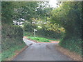
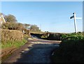
10
Bridge beneath A39
The lane from Bradavin on its way to Westleigh.
Image: © Derek Harper
Taken: 1 Dec 2019
0.23 miles