IMAGES TAKEN NEAR TO
Gammaton Road, BIDEFORD, EX39 4FG
Introduction
This page details the photographs taken nearby to Gammaton Road, EX39 4FG by members of the Geograph project.
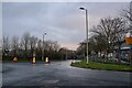
The Geograph project started in 2005 with the aim of publishing, organising and preserving representative images for every square kilometre of Great Britain, Ireland and the Isle of Man.

There are currently over 7.5m images from over14,400 individuals and you can help contribute to the project by visiting https://www.geograph.org.uk
Image Map
Images are licensed for reuse under creativecommons.org/licenses/by-sa/2.0
Notes
- Clicking on the map will re-center to the selected point.
- The higher the marker number, the further away the image location is from the centre of the postcode.
Image Listing (17 Images Found)
Images are licensed for reuse under creativecommons.org/licenses/by-sa/2.0
Image
Details
Distance
2

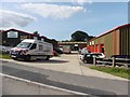
East-The-Water : Coates Road
Looking along Coates Road off Manteo Way.
Image: © Lewis Clarke
Taken: 5 Feb 2021
0.04 miles

4
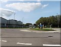
Mini-roundabout on Alverdiscott Road
Image: © Roger Cornfoot
Taken: 10 Sep 2020
0.05 miles
5
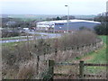
Pot Black
A factory that makes snooker equipment on the eastern outskirts of Bideford.
Image: © Jonathan Billinger
Taken: 17 Jan 2008
0.05 miles
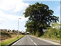
6
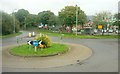
Roundabout on Alverdiscott Road
Behind the trees is Bideford Business Park.
Image: © Derek Harper
Taken: 27 Sep 2016
0.05 miles
7
East-The-Water : Alverdiscott Way
Looking along Alverdiscott Way.
Image: © Lewis Clarke
Taken: 5 Feb 2021
0.05 miles
8
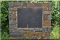
A plaque at the top of Manteo Way, the Bideford East the Water Industrial Link Road
Image: © Roger A Smith
Taken: 6 Jun 2011
0.07 miles
10
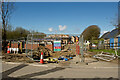
New homes surrounding Kingsley House on three sides
Image: © Roger A Smith
Taken: 13 Apr 2023
0.11 miles