IMAGES TAKEN NEAR TO
Clifton Street, BIDEFORD, EX39 4EX
Introduction
This page details the photographs taken nearby to Clifton Street, EX39 4EX by members of the Geograph project.
The Geograph project started in 2005 with the aim of publishing, organising and preserving representative images for every square kilometre of Great Britain, Ireland and the Isle of Man.

There are currently over 7.5m images from over14,400 individuals and you can help contribute to the project by visiting https://www.geograph.org.uk
Image Map
Images are licensed for reuse under creativecommons.org/licenses/by-sa/2.0
Notes
- Clicking on the map will re-center to the selected point.
- The higher the marker number, the further away the image location is from the centre of the postcode.
Image Listing (78 Images Found)
Images are licensed for reuse under creativecommons.org/licenses/by-sa/2.0
Image
Details
Distance
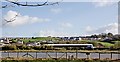
2
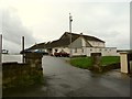
Polyfield Centre, Avon Road, East the Water
Image: © Roger A Smith
Taken: 2 Dec 2009
0.05 miles
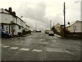
3
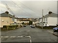
The junction of Clifton Street with Avon Road facing Torrington Lane
Image: © Roger A Smith
Taken: 2 Dec 2009
0.05 miles
4
The junction of Clifton Street with Avon Road facing the river
Image: © Roger A Smith
Taken: 2 Dec 2009
0.05 miles
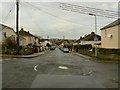
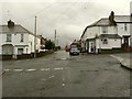
5
The junction of Clifton Street with Avon Road facing Polyfield
Image: © Roger A Smith
Taken: 2 Dec 2009
0.05 miles
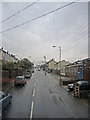
6
The junction of Clifton Street with Avon Road facing Sentry Corner
Image: © Roger A Smith
Taken: 2 Dec 2009
0.05 miles
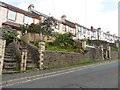

10
New houses at Polyfields, East the Water
See also: Image
Image: © Roger A Smith
Taken: 30 Jan 2016
0.10 miles