IMAGES TAKEN NEAR TO
Needs Drive, BIDEFORD, EX39 3TB
Introduction
This page details the photographs taken nearby to Needs Drive, EX39 3TB by members of the Geograph project.
The Geograph project started in 2005 with the aim of publishing, organising and preserving representative images for every square kilometre of Great Britain, Ireland and the Isle of Man.

There are currently over 7.5m images from over14,400 individuals and you can help contribute to the project by visiting https://www.geograph.org.uk
Image Map
Images are licensed for reuse under creativecommons.org/licenses/by-sa/2.0
Notes
- Clicking on the map will re-center to the selected point.
- The higher the marker number, the further away the image location is from the centre of the postcode.
Image Listing (9 Images Found)
Images are licensed for reuse under creativecommons.org/licenses/by-sa/2.0
Image
Details
Distance
1
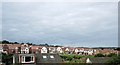
College Park, Bideford formerly Morton Park playing fields
Image: © Roger A Smith
Taken: 20 Sep 2015
0.02 miles
2

Needs Drive, College Park, Bideford
Formerly Morton Park playing fields close to where the pavilion stood.
Image: © Roger A Smith
Taken: 20 Sep 2015
0.02 miles
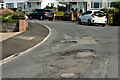
3

A structural failure in the road surface on Abbotsham Road
Image: © Roger A Smith
Taken: 3 May 2023
0.10 miles
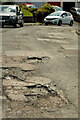
4

A structural failure in the road surface on Abbotsham Road
Image: © Roger A Smith
Taken: 3 May 2023
0.11 miles
5
A structural failure in the road surface on Moreton Avenue
Image: © Roger A Smith
Taken: 13 Jul 2023
0.18 miles
6
A structural failure in the road surface on Moreton Avenue
Image: © Roger A Smith
Taken: 13 Jul 2023
0.18 miles

8
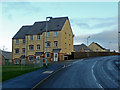
New townhouses
By the Abbotsham Road, Bideford; viewed from the west towards the town centre.
Image: © Jonathan Billinger
Taken: 16 Jan 2008
0.20 miles
9
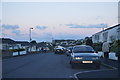
Bideford : Moreton Park Road
A residential area and the road heading through.
Image: © Lewis Clarke
Taken: 23 Nov 2014
0.24 miles